
Vegetation
|
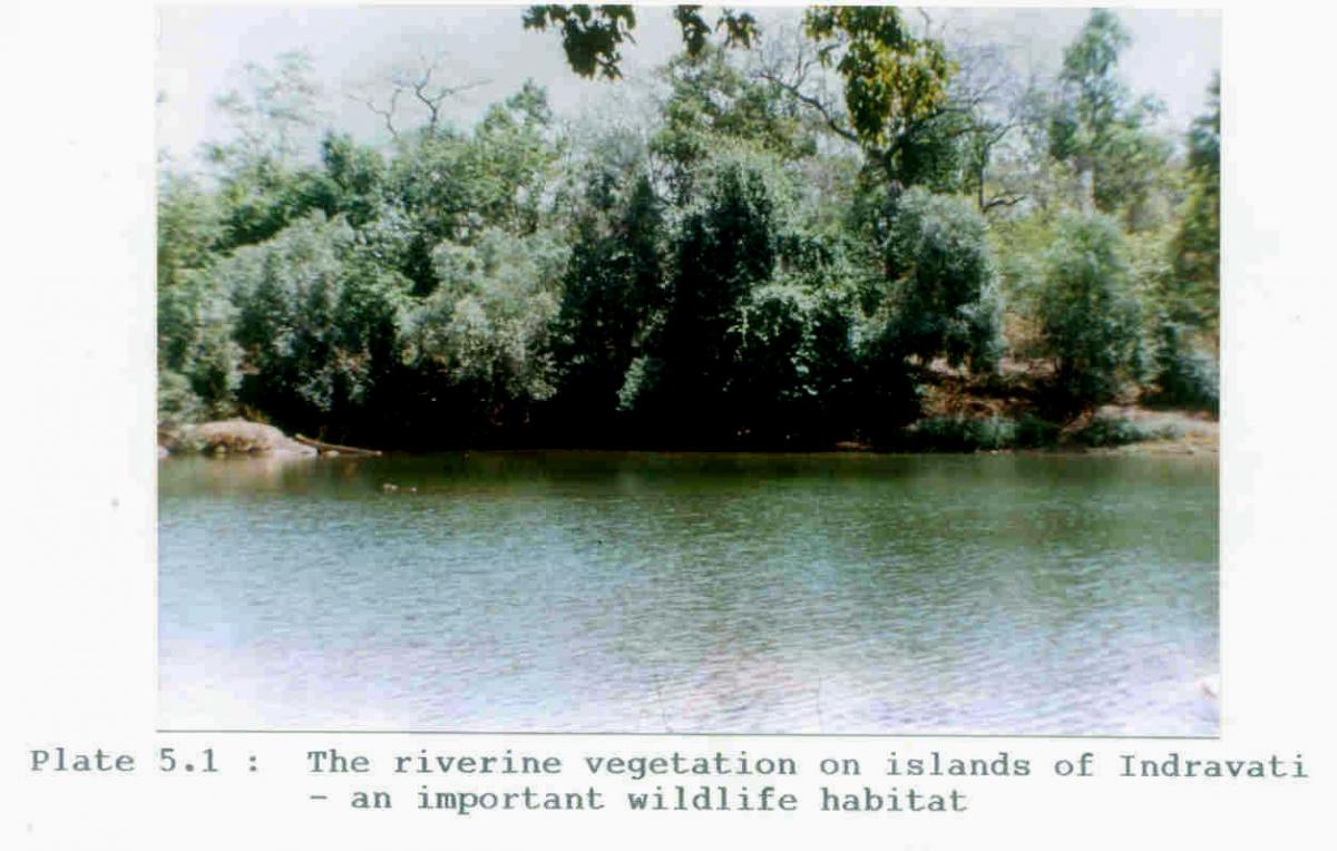
The knowledge of vegetation composition of any region is an essential prerequisite for the study of ecosystems. An in depth knowledge of plant diversity is the basis of identifying habitat suitability for different faunal species resident in the area including those threatened, endangered or rare. Further, it provides an understating of the variety of plants being utilized by the local people. This is important for projects where tribal societies are involved, because such an understanding would give clues to selection and planning of the rehabilitation sites. The forest working plan for Bastar recognizes four distinct categories of vegetation (following Champion and Seth 1968): (i) Moist Peninsular Sal Forest (ii) Moist Peninsular Valley Sal (iii) Southern Moist Mixed Deciduous Forest and (iv) Slightly Moist Teak Forest. However these categories are not as such recognizable in the submergence area. The probable reasons that can be attributed to this are changes which have been brought about in the ecology of the area as a result of accumulated human action. More probable and apparent are the reasons associated with past clearing for shifting cultivation. According to Meher - Homji (1983) the forest types of the study area belong to the Shorea – Terminalia – Adina series of the Sal type intermediate between dry and moist categories and Shorea – Buchanania - Cleistantus series of the dry deciduous Sal type. Based on the proportion of Sal and Bamboo present , the following forest types or communities are recognizable in the study area. Sal forest These occupy flatter areas such as ridge top plateaux. The average percentage of Sal trees in this type is 65% (Appendix 5.1). The forests have stratal differentiation, are moderately closed and top height is not less than 30 m and average tree density is 827/ha. Sal mixed forest Unlike the Sal forest on the plateau which covers large areas, the Sal mixed type is found in valleys and lower slopes. In this type of forest there is a larger percentage of miscellaneous species (Appendix 5.2) in different strata (upper, middle and under storey). The canopy is comparatively less closed in Sal mixed forest when compared to Sal forest. The average tree density is 910/ha. The strata recognizable in Sal forest and the Sal mixed forest area: 1. Upper storey – Besides shorea robusta, main species present are Xylia xylocarpa, Adino cordifolia, Anogeissus latifolia¸Pterocarpus marsupium, Terminalia tomentosa, Lannea coromandelica Albizia sp. and Schleichera oleosa. 2. Intermediate storey – Buchanania lanzan, Cleistanthus collinus, Largestroema parviflora and Diospyros montana are common species of the under storey. 3. Undergrowth – The undergrowth is sparse and is represented by Holarrhena antidystenrica, Zizyohus zylopyra and Woodfordia floribunda. The common climbers of these forest type are Bauhinia vahlii and Dalbergia volubilis. A count of Sal seedling in 10 m radius sampling plots suggests the presence of Sal regeneration in approximately 60% of the sample plots, the regeneration density rating being moderate i.e. 10 – 15 saplings/plot or 330 – 450/ha. This regenerating Sal, however, is variously scorched (partially and completely) by ground fires frequent in the forest during summer. Comparing these forests with the standard forest classification system, the Sal forest and the Sal mixed forest well represent the Shorea – Terminalia – Adins series of Meher – Homji (1983). Sal and Sal mixed forests also correspond to moist Peninsular Sal type of Champion and Seth (1968). Miscellaneous forest This type is widely distributed in the study area and frequently occurs in patches within Sal forest in the valley, at the foot hills and also on hill slopes. The average height range of the forest is 18 – 20 meters. The average tree density is 695/ha. The upper canopy is distinctly composed of Anogeissus latifolia, Buchanania lanzan, Largerstroemia parvoflora, Garuga pinnata, Chloroxylon swietenia and Cassia fistula. Meduca indiaca is confined to plains only while Boswellia serrata is confined to higher slopes. In the middle storey, occurs Cleistanthus collinus which has the highest percentage composition (34.6%). To a lesser extent this storey is represented by Bauhinia recemosa, and Dalbergia paniculata. Holarrhena antidysentrica, Flacourtia ramontvhii and Gardinai latifolia are the understorey plant species associated with miscellaneous forest type (Appendix 5.3). The common climbers of miscellaneous forest of the study area are Bauhinia vahlii, Butea superba and Ventilago calyculata. Bamboo-mixed forest Miscellaneous forest Bamboo mixed forest correspond to the transition between Dry Deciduous Sal and Moist Peninsular Sal types of Champion ad Seth (1968). Meher – Homji (1982) has recognized a Shorea – Buchanania – Cleistanthus series of Dry Deciduous Sal Type also reported from Bastar. It is likely that the predominantly miscellaneous forest and bamboo-mixed forests having very low percentage of Sal but with Cleistanthus collinus comprising 30% and 48% in miscellaneous and bamboo-mixed types respectively, and having Buchanania lanzan and Anogeissus latifolia in upper slopes, represent the Shorea – Buchnania-Cleistanthus series of the Meher- Homji classification (appendix 5.4). Riverine forest Although occurring on the river banks of Indravati and its major tributaries and on river islands, this is very important from the angle of wildlife (Plate 5.1). The common species are Mangifera indica, Terminalis anjuna, Ficus glomorata, Mallotus philippinensis, Diospyros peregrine and Pongamia pinnata. The islands are fairly open and have Syzgium heyneanum, Homonia riparia, Salix tetrosperma and Scirpus growing on the edges. Some of the larger islands carry riverine grasslands of crucial value as wildlife habitat, particularly for wild buffalo. Vetiveria zizaniodes and Curcuma longa are the common grass species on these islands. Degraded forests This type occurs at forest edge, crop field borders in the valley and degraded lands. These are under stocked and open as a result of unrelenting human pressures. The associated species are Terminalia tomenta, Diospyros sp. Madhuca indica, Buchanania lanzan and Boswellia serrata. Details of percentage composition, frequency of occurrence and density in each forest type are given in the appendix 5.1 – 5.4. Table 5.0: Distribution and proposition of different forest types in the study area.
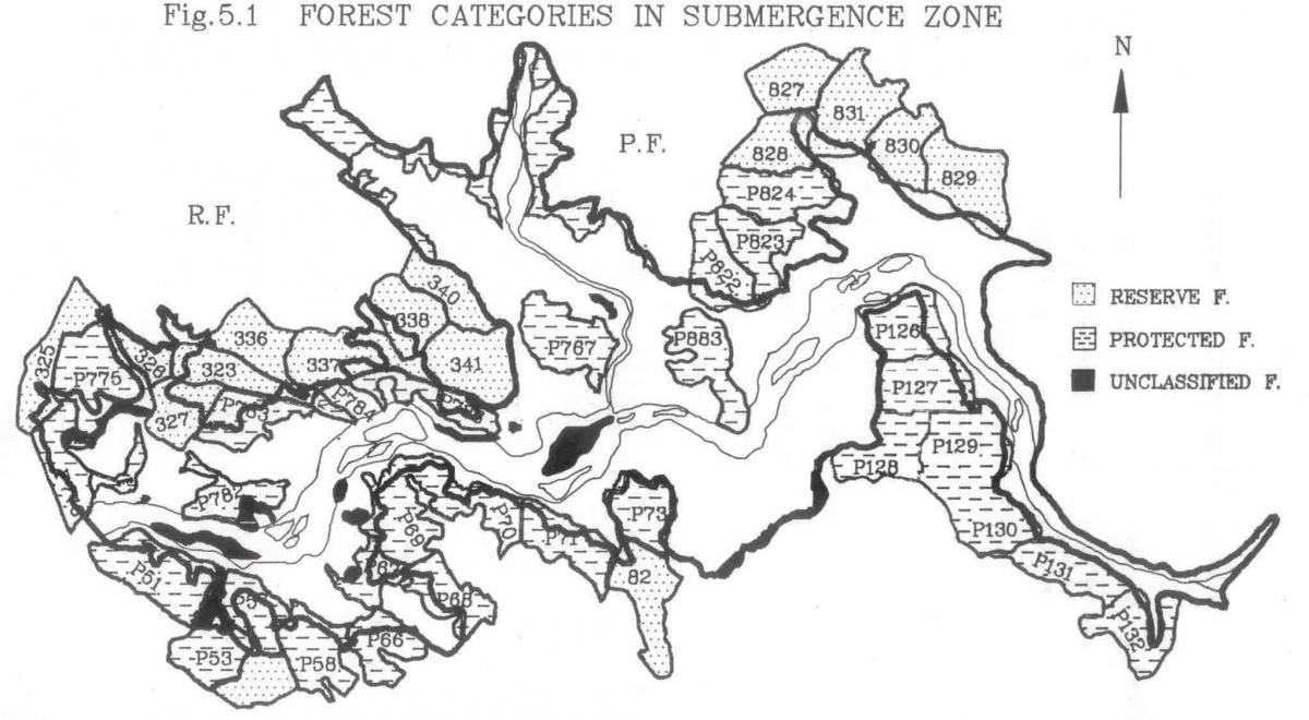
Forest of the study area belong to three legal categories (Fig. 5.1) viz. Reserved Forest (RF). Protected Forest (PF) and unmarcated forests, more commonly known as Orange Forest Areas (OF) and occurring usually close to villages. PF and OF are more degraded than the RF occurs in bigger blocks. The break of project by legal categories is as follows: -
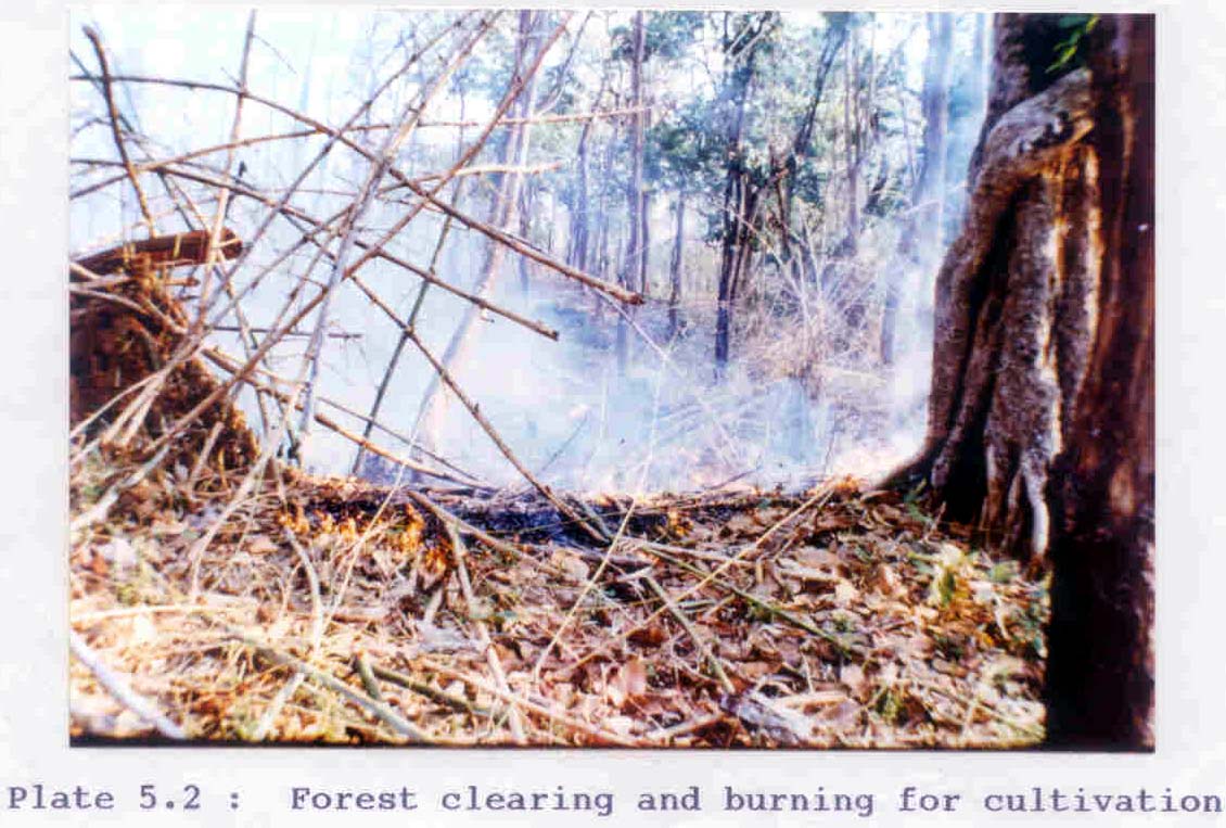
The survey of the impact areas (more specifically of the submergence area) reveals that the major portion of the PF and OF are under heavy biotic interferences from fire, heavy grazing and human use (Plate 5.2). Table 5.1 compares the extent of biotic interference and associated effects like weed abundance and erosion in the protected forest and orange areas within the submergence zone. Our comparison is based on the number and percentage of sample plots in PF and OF that have low (0-1) and high values (2-3) for the measurement of variables like woodcutting, weed abundance, erosion level, cattle dung abundance and the tree density. Table 5.1: Disturbance level in Protected forest and Orange forest.
0-None 1-Low 2-Medium 3-High
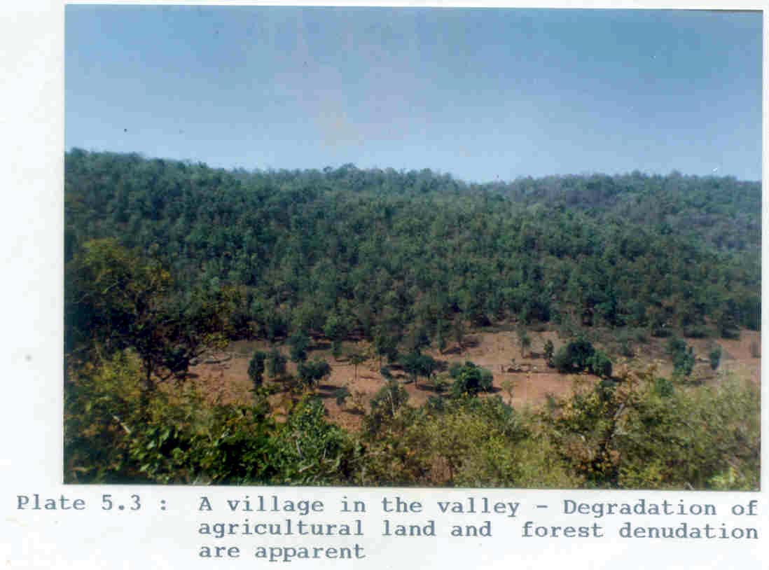
It is inferred from the above table that there is no significant difference in the resultant impact of biotic factors on Pf and OF. The only significant difference is found to be in the abundance of cattle dung present in PF and OF. As orange area are undemarcated area and people have nistar rights for MFP collection, cattle grazing and bringing out of dead and decayed wood, the OF are more open to exploitation. The level of this shrinkage, fragmentation and degradation, however, is more pronounced in the valley and in riparian strips where bulk of habitation exists (Plate 5.3). Table 5.2 is a summary of the data collected using habitat score sheets (already discussed in chapter on methodology) for an assessment of the status of these flatter areas. Figures in the columns Low, Medium and High represent the number of sample points falling in each of the categories of degradation for the variables listed in the table. Forest clearance by villagers for habitation and cultivation are counting to decimate forested area significantly. Table 5.2: Degradation factors operating in the forest of the study area.
*A total of 47 sample points were studied. Based on the total score of the variable on each sample point, following three categories of degradation were established.
All the forty seven sample points fall in at least one of the degradation classes while most of them fall in the category of moderate degradation. Although no definite relationship can be established between the degradation category and vegetation of the sample areas, it cannot be ruled out that grazing, wood cutting timber operations presence of human settlements reduce the potential of any area to sustain wildlife by directly becoming the responsible factors for competition for food with domestic animals and also as habitat destruction factors.
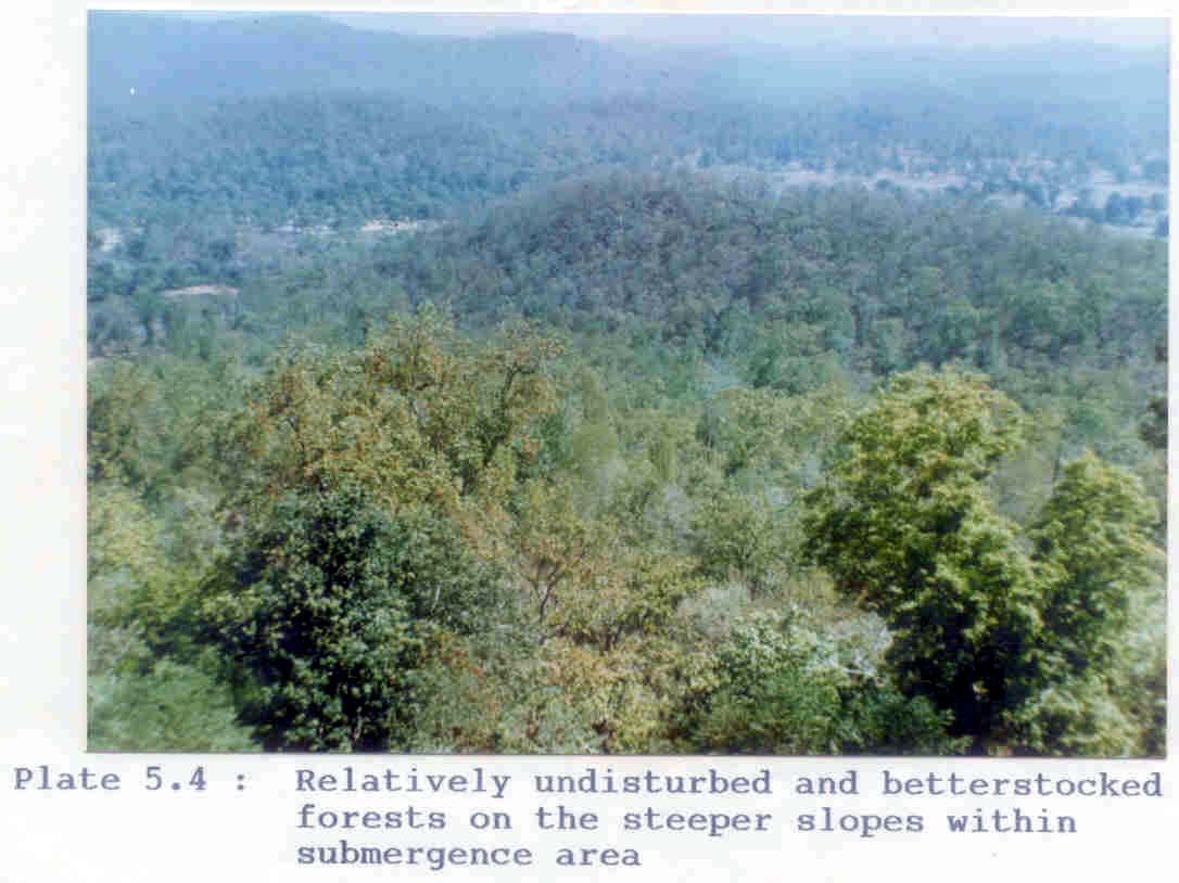
Irrespective of whether it is a PF or an Of the forest situated away from habitations and those found on the steeper slopes attract less pressure due to difficult access and thus have remained better (Plate 5.4). These less disturbed forests have better structure in top, middle and lower strata and have good tree density (already discussed in the section vegetation communities) when compared to the sparse forest patches (found in habitated areas) with scattered trees and depleted lower strata. Wood cutting and pollarding of Sal are major man made disturbance factors operating here. An assessment of the status of these forests on steeper slopes based on the total score count for different variables (wood cutting, pollarding, erosion and fire) on each sample point give the allocation to the category class as under:
Data is based on 52 sample points. Different village transects showed varying intensities of pole cutting (Table 5.3). This intensity appeared to be related to the accessibility and village population. Transect through the forest patch around Binta, the largest village in the study area with 773 residents located in a very flat area of the forest showed the most intensified wood cutting at first sample point (86.2%). Pushpal with 38 residents, situated on a relatively higher slope extracted wood form the forest to a lesser extent (25.0%). Our results from five different village transects show that pole cutting occurs within a distance of 1.5 km from any village, beyond which the cutting intensity is negligible. Correlation between wood cutting and distance from village r = -0.6498, P < .001 n=30. Table 5.3: Percentage of trees cut on transects
Observations on the need for poles of particular species did not indicate very specific requirement of the tribals. The most commonly cut species in the middle storey was Cleistanthus collinus (Table 5.4). Other middle storey species cut in these forest patches of Bastar are Diospyros melanoxylon, Xulia xylocarpa, Largestromoea parviflora and Buchanania lanzan. In addition to these species of middle storey, Anogeissus latifolia, Garuga pinnata, Shorea robusta, Adina cordifolia and Bridelia retusa of the higher strata are also cut in varying proportions. Table 5.4: Analysis of pole cutting intensity in respect to frequency occurrence tree species.
Based on GBH measurements, all trees within the forest could be placed in three girth classes (Table 5.5). Most trees were in the lower girth class (20-49 cm) and few in subsequent girth classes. Assessment based on GBH measurement suggests consistency in requirement for poles of specific girth by residents of all villages. In all village transects, maximum number of poles were removed from trees of girth class –I. The preference for trees of this GBH class is based on the capability of these trees to provide poles for agricultural implements Kanvar (used for transporting material), housing material for cattle shed and renovation of ‘machan’ (crop protection hides). Poles from trees of girth class-II (50-90 cm) are used for making support frames for houses, but both the proportion of wood cutting and abundance of trees in this girth class are relatively low. Table 5.5: Percentage of trees cut and trees available for cutting under different girth classes
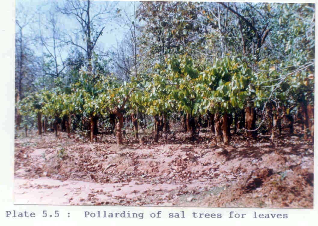
The existing natural forests of Bastar are extremely important to the tribals of the area. Apart form the social and ritualistic needs that are met by these forests, these forests are only source of wood for fuel and timber for agricultural implements and house building. Depending on the topography of the area, fertility of the soil, proximity to water source and availability of good forest patch, these tribals concentrate more in certain parts of the forest for their subsistence on forest. Although frequency of occurrence of difference species vary in the forest, cutting for poles is not determined by frequency of occurrence of difference species vary in the forest, cutting for poles is not determined by frequency of occurrence (chi square calculated = 14.6; tabular value for 5 df at 0.5 level of probability – 11.07). Sal (shorea robusta) seems to have found most versatile use in tribal culture. Cutting intensity as expressed by percentage of poles cut is maximum for Sal. Sal is highly preferred for its durable timber and for its leaves and seeds which are used for making plates and extracting oil respectively. It was observed that people do not permit the Sal trees to grow beyond the pole stage. As a result of repeated cutting, the condition of forest is much degraded in some areas as these hold high stumps with pollards and young poles only (Plate 5.5). Flora The situation of Bastar is roughly central on north south axis although closer to the hills of southern India than to the outer hills of the Himalayas. The vegetation, therefore, might be expected to approximate more to the southern flora. The distance separating the northern end of southern ghats from our area is not such to present any serious obstacle to dispersal of plants (Mooney 1942). The flora of the study area is similar to that of adjoining areas of eastern Orissa and north western Maharashtra. Indravati river provides one of the routes by which seeds and fruits might have inter dispersed either way. Forest connections between Bastar and Orissa and Bastar and Maharashtra are almost interrupted. From the study area we recorded 181 plant species (Appendix 5.5). A separate list of 22 plant species recorded in Indravati Tiger Reserve and Bhairamgarh Wildbuffalo Sanctuary, is also presented (appendix 5.6). Species composition Our collection of 181 plants in three months of summer period does not represent a collection of major part of the floral wealth of Bastar. The forest of Bastar are much more diverse. Subramanyam and Henry 1966 published a list of 481 species of vascular plants which was the outcome of three collection tours. Saxena and Khotele 1972 reported additional 319 species of vascular plants which were reported for the first time from Bastar.
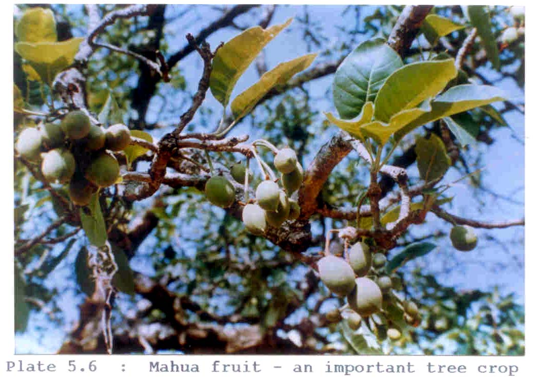
The family represented by maximum number of plants in our collection is Leguminoseae (20) followed by Utricaceae (11) and Rubiaceae (10). Twenty three families are represented only by a single member. The plant taxa diversity in the proposed submergence zone is well represented mainly because of stratal differentiation in the vegetation communities. Diverse relief and topography ranging from valley are to wide variations in slope and aspect of the hillocks also provide for diversity in flora to some extent. The plant taxa were crosschecked with ‘The threatened plants of India’ (Jain and Rao 1983), ‘Endemic plants of the Indian Region’ (Ahmedullah and Nayar 1987) and ‘Red Data book for Indian Plants’ (Nayar and Sastry 1987). None of the species fall in endangered, rare or threatened category of plants. While this may be true, the point that is important is that there are few samples of such less impacted forests and hence conservation of these forests is essential for biodiversity. Economic importance Utility based classification of the identified plants are done by retrieving the information form native users in the study area. Out of the total 181 plants, 84 (46.4%) are used in one or more ways by the tribal society. The largest group id that of edible plants or their parts numbering upto 43 (51% of the total plants used). Followed by minor forest products (22.62%) and plants for medicinal purposes (14%). It is likely that the actual number of plants used by tribal physicians is much higher, yet our record is low because such information is difficult to elicit in a short term survey. Nearly 6% of the plants are used in manufacturing of agricultural implements and 5% of the total plants have versatile uses e.g. Madhuca indica, Phoenix acaulis and bamboo (Plate 5.6). The palms Caryota urens and Borassus flabellifer yield stem fluids called ‘Sulphi’ and ‘Toddy’ respectively, which readily ferment in local brews are much favoured by the people. Specific uses of plants are discussed in detail in the chapter describing the dependence of people on forests. Although the collection and records are scarcely adequate to give conclusive results, yet an indication of the proportions of tree, shrub and herb component present in the flora of the study area and the numerical strength of some of the important families from the analysis of the list is also expressed from the analysis of list.
|
||||||||||||||||||||||||||||||||||||||||||||||||||||||||||||||||||||||||||||||||||||||||||||||||||||||||||||||||||||||||||||||||||||||||||||||||||||||||||||||||||||||||||||||||||||||||||||||||||||||||||||||||||||||||||||||||||||||||||||||||||||||||||||||||||||||||||||||||||||||||||||||||||||||||||||||||||||||||||||||||||||||||||||||||||||||||||||||||||||||||||||||||||||||||||||||||||||||||||||||||||||||||||||||||||||||||||||||||||||||||||||||||||||||||||||||

Last Updated: October 3, 2015


