|
The term baseline studies entered the environmental literature 25 years ago and almost at the same time when the concepts of EIA were emerging. The term `baseline' refers to a description of some aspects of the physical, biological and social environment, which could be affected by the development project under consideration (Walsh, 1983).
Initial baseline data collection programme thus characterises the pre-project state and is directed towards establishing valid description of selected environmental components prior to the onset of the project.
This section of the report is a compilation of information on baseline variables of wetlands and forested areas that are expected to be altered in the event of the implementation of the proposed CCKT Pipeline Project.
3.1 WETLANDS
Wetlands are transitional zones that occupy an intermediate position between dry land and open water ecosystems dominated by the influence of water and, possess characteristics of both terrestrial and aquatic ecosystems and properties that are unique in their own (WWF, 1992). As a result, they support a wide array of ecologically important species of flora and fauna, some of which are rare, vulnerable and endangered. Apart from being life support system for many wildlife species in their critical stages of biological cycles, they also play a major role in enhancing the ecological, genetical and socio-economic diversity of a region.
3.1.1 Rivers
Some of the areas en route the proposed pipeline corridor forms the catchment of major rivers of Southern India such as Periyar, Chalakudi and Amaravati (Fig 3.1). Apart from these major rivers, the proposed pipeline would traverse through several smaller rivers and streams. The proposed pipeline would traverse through the major rivers at 19 points for a total length of 1.8 km. The hydrological parameters of the rivers identified for the study are given in Table 3.1.
Table 3.1 Major rivers en route the proposed pipeline.
|
Sr.No.
|
Name of the river
|
Approx. width (m)
|
Depth (m)
|
Seasonality
|
Chainage (km)
|
|
1
|
Kaniyampuzha
|
150
|
3
|
Perennial
|
2.0
|
|
2
|
South periyar
|
90
|
5
|
Perennial
|
16.4
|
|
3
|
North periyar
|
225
|
4
|
Perennial
|
24.1
|
|
4
|
Chalakudi
|
125
|
3
|
Perennial
|
27.4
|
|
5
|
Kurumalipuzha
|
50
|
2
|
Perennial
|
55.7
|
|
6
|
Bharatpuzha
|
450
|
3
|
Perennial
|
97.6
|
|
7
|
Amaravati
|
300
|
dry river bed
|
Seasonal
|
312.5
|
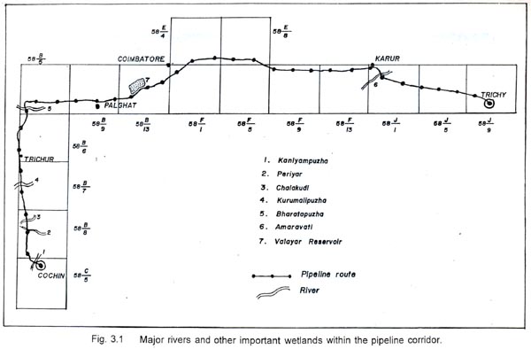
All the rivers, except Amaravati, are perennial. The river banks are generally dominated by coconut trees and are also used by local villagers for bathing, fishing and sand mining.
Wildlife values
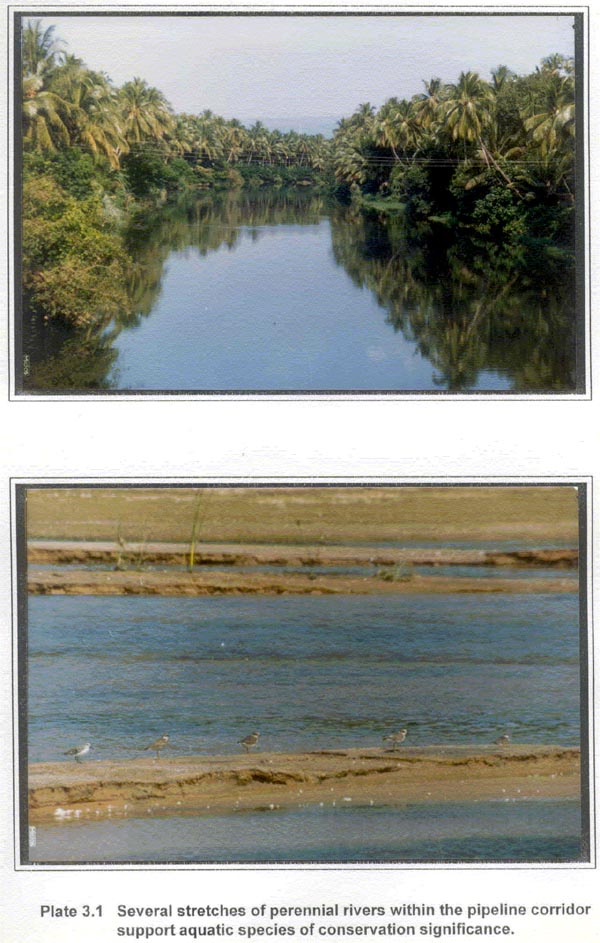
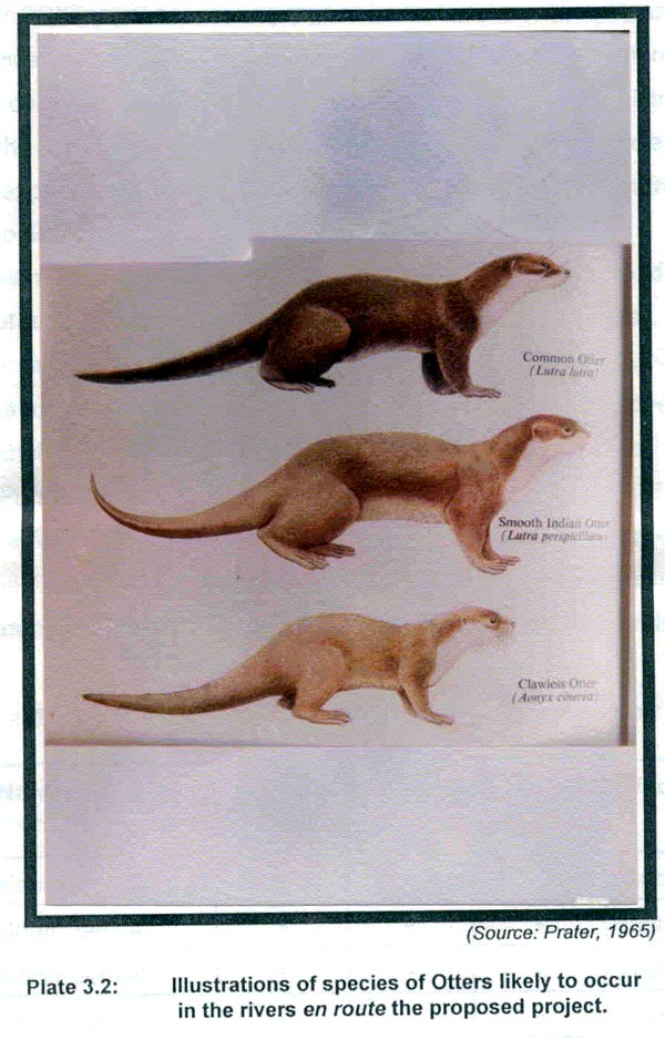
Despite several biotic interferences of varying magnitude, from all the rivers, an array of aquatic species of conservation significance were reported (Plate 3.1). Discussions with local people revealed that four groups of aquatic fauna viz. mammals, reptiles, fishes and birds, are represented in these rivers. The mammalian fauna of these rivers is likely to be represented only by otter species. The present distribution range of otter species in Indian rivers (Pocock, 1941; Prater, 1965; Hussain and Choudhury, 1993), reveals that all the three species of indian sub-continent viz. Smooth coated otter (Lutra perspicillata), Common otter (Lutra lutra) and Oriental small clawed otter (Aonyx cinerea) (Plate 3.2), are likely to occur in Kaniyampuzha, South Periyar, North Periyar and Chalakudi rivers. All the three species of otters are highly threatened (IUCN, 1990) and listed as scheduled species of the Indian Wildlife (Protection) Act, 1972 (Anon., 1972). Of these, the oriental small clawed otter is the rarest of all and is listed in Schedule - I and the common and Smooth Coated Otter are listed in Schedule - II of Indian Wildlife (Protection) Act (1972). The time frame in which the EIA study for CCKT pipeline was required to be undertaken was not sufficient to gather direct evidences of otter species reported from the stretches of different rivers within the pipeline corridor. Hence, the sources of information on otter distribution in these rivers are the published documents, interactions with wildlife scientists, who are recognised experts in the field of otter ecology, and the reliance on the knowledge of the local people.
Reptilian fauna is likely to be represented by turtles. No direct or indirect evidences of turtle were recorded during the study period. However, local fishermen confirmed their presence in all the rivers, other than Amaravati. Based on their distribution and habitat requirements, Indian Black Turtle (Melanochelys trijuga) and Indian flapshelled Turtle (Lissemys punctata) are likely to occur in these rivers (Bhupathy Pers. Comm., 1995).
Wildlife values of major rivers en route the proposed pipeline, presented in Table 3.2, are based on subjective assessment of the conservation significance of the broad faunal groups and their representative species, discussed earlier in the text.
Table 3.2 Major rivers en route the proposed pipeline and their wildlife values.
| Sr.No. |
Name of the river |
Species presence
|
Wildlife values |
| Otter |
Turtle |
Fishes |
| 1 |
Kaniyampuzha |
+ |
+ |
+ |
Moderate |
| 2 |
South periyar |
+ |
+ |
+ |
High |
| 3 |
North periyar |
+ |
+ |
+ |
High |
| 4 |
Chalakudi |
+ |
+ |
+ |
High |
| 5 |
Kurumalipuzha |
- |
+ |
+ |
Moderate |
| 6 |
Bharatpuzha |
- |
+ |
+ |
Moderate |
| 7 |
Amaravati |
- |
- |
+ |
Low |
Common fish species reported from rivers of this part of Kerala and Tamil Nadu include mullet (Mugil cephalus), pearl spot (Etroplus suratensis), puntius (Puntius sp.), wallago (Wallago attu), etc. (Rajendra Pers. Comm., 1995). Common bird species recorded from these rivers, during the study period, include large egret (Ardea alba), little egret (Egretta garzetta), little ring plover (Charadrius dubius), common sandpiper (Tringa hypoleucos), grey wagtail (Motacilla cinerea), white breasted kingfisher (Halcyon smyrnensis), common blue kingfisher (Alcedo atthis), pond heron (Ardeola grayii), little cormorant (Phalacrocorax niger) and river tern (Sterna aurantia).
Direct and indirect sightings of animal species in South Periyar, North Periyar and Chalakudi rivers and the secondary information on wildlife values provided by the local people and wildlife survey reports, establish the significance of these rivers as excellent wildlife habitats (Table 3.2).
3.1.2 Reservoir
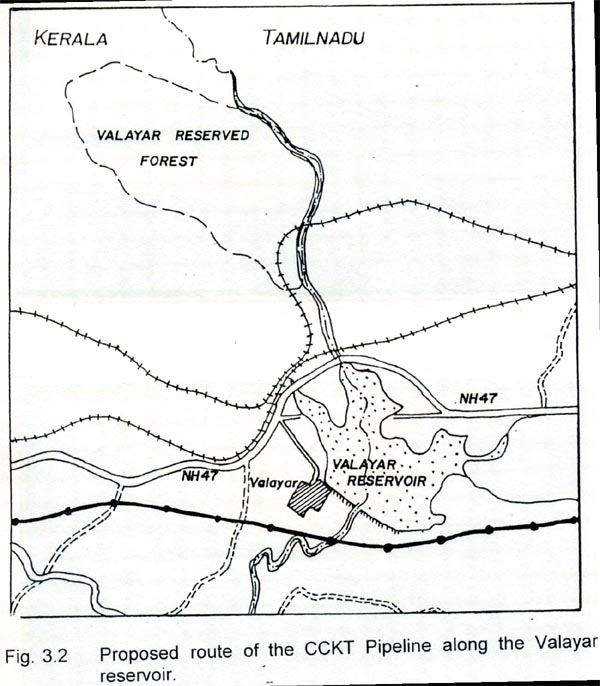
The pipeline between Shoranur and Coimbatore is proposed to be routed along the fringes of Walayar reservoir (Fig. 3.2). The Walayar reservoir falls partly in Tamil Nadu and in Kerala state, built across the river Walayar which flows from the forests in the southern tip of Western Ghats, just north of Palaghat gap (Plate 3.3). In its full capacity the reservoir generally submerges around 600 acres of land during the monsoon. During the summer months, between March to May, the reservoir generally becomes dry. Although, the short span of this study was a major limitations in the study of avian diversity of the Walayar reservoir, the published information provide substantial reasons to consider this wetland as a potential habitat for large number of aquatic birds. According to the mid winter waterfowl counts, 807 water birds of 32 species were recorded from this reservoir (IWRB, 1993). Praveen et al. (1994) reported 178 bird species from this reservoir and the adjacent paddy fields, low lying teak forest and moist deciduous forest. Major species reported from the reservoir are the Storks viz. Black stork (Ciconia nigra), Openbill stork (Anastomus oscitans), Lesser Adjutant stork (Leptoptilos javanicus) and Painted stork (Mycteria leucocephala). Other species of aquatic birds reported from the Walayar reservoir are Pintail (Anas acuta), Lesser whistling teal (Dendrocygna javanica), Spotbill duck (Anas poecilorhyncha), Large and Little cormorants (Phalacrocorax carbo; P. niger), White ibis (Threskiornis aethiopica), Egrets, Herons, Plovers like Kentish (Charadrius alexandrinus) and Little ringed plover (Charadrius dubius). The complete checklist of the birds is presented in Annexure - I.
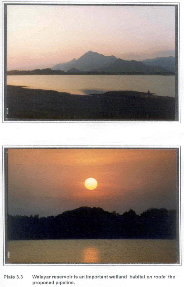
The water fowl census of Walayar reservoir clearly establishes its importance as one of the crucial waterfowl habitats in Kerala. Of the different storks reported from Walayar reservoir, the sighting of Black stork and Lesser adjutant storks in this reservoir is particularly notable. In addition sighting of Black bellied tern (Sterna acuticauda) and Bar headed goose (Anser indicus) is also remarkable (Yoganand and Ali, in press). The first sighting of Black stork was reported from Kerala only a decade ago (Neelkanthan et. al, 1993). Even since then, these have had rare occurrence in South India (Ali and Ripley, 1978).
As a large predator or a scavenger, occupying the top of the food chain, the presence of Black storks is an important index of the health of ecosystem. It can therefore serve as a flagship species for conservation effort. At the International Workshop on Conservation and Captive Breeding of Storks held at Georgia in 1986, the Black storks were considered to be vulnerable at a Global level (Coulter et. al, 1989). Black bellied tern and Bar headed goose have also been recommended for listing in the globally threatened species (Perennou, et. al, 1994).
The variety of bird species as indicated from the appended checklist (Annexure -I) for Walayar and the reports of reappearance of Black stork (Paper clipping from local News Paper Malayalam Manorama) appended as Annexure - II, has only re-established the conservation significance of this waterbody as a waterfowl habitat. The potential of Walayar reservoir as a waterfowl habitat has been greatly undermined due to several threats associated with the industries like Malabar cement factory and ACC cement mines. Deforestation in its catchment area and pollution of this water body also pose a serious threat for most aquatic species.
Personal communications with Shri L. Namashivayan an active naturalist from Palghat, Kerala have provided some indications of the possibility of this area being protected as a bird resort. Moreover, the reservoir and its fringes offer an ecotonal area for most bird species of the adjacent teak forest. These teak forests support varied avifauna such as Forest spotted owlet (Athene blewitti), Ceylon frogmouth (Batrachostomus moniliger and Hornbills (Praveen et. al, 1994), all of which have been listed as Schedule -I of Indian Wildlife (Protection) Act (1972). As the proposed pipeline route is aligned along the fringes of this wetland, its likely impacts of it on this reservoir need to be assessed with utmost care.
3.1.3 Marshes
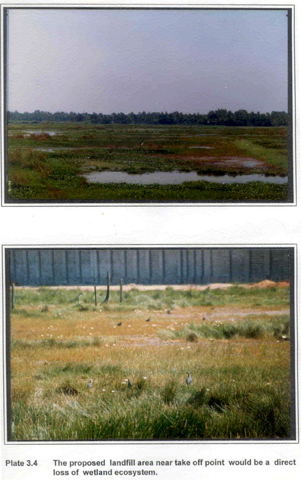
Marsh is an area having water saturated sediment with no or little standing water among the vegetation (Wetzel, 1975). Marshes are known for their concentric zones of plants of various life forms (e.g. submerged, free floating, rooted floating and emergent types) surrounding a relatively deeper, open water area. Due to these typical structural characteristics, marshes form important wetland habitats of significant wildlife values (Weller, 1978). Some area on the southern side of BPCL complex at Irumbanam have been found to be an excellent marshland (Plate 3.4). This marshland is divided into two unequal halves by the pipeline bund that leads to the railway line (refer drawing No. BPCL/CKPL/10 in Annexure IV). The wetland includes aquatic plants like Eichhornia crassipes, Eleocharis palustris, Nymphaea sp., Nymphoides sp.,. A few grass species such as Pennisetum polystachyon and Cenchrus ciliaris form interspersed tufts in the entire wetland. This wetland offers excellent feeding grounds for many aquatic birds. During the present study several species of aquatic birds including Purple moorhen (Porphyrio porphyrio), Grey heron (Ardea cinerea), Purple heron (Ardea purpurea), Little egret (Egretta garzetta), Tern (Sterna sp.), White breasted kingfisher (Halcyon smyrnensis) and Grey wagtail (Moticilla cinerea) were recorded from these marshy areas.
3.2 FORESTS
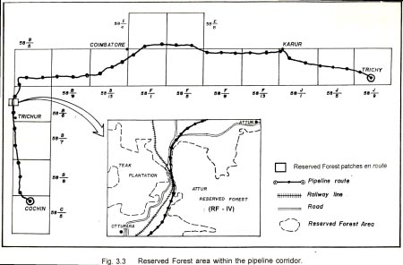
Four patches of Reserved Forest (RF) of Trichur forest division fall within the pipeline corridor of CCKT Project (Fig. 3.3). Of these, RF I is a part of Pattikad range, while RF II, III and IV are a part of Machad range of the Trichur forest division. All the above RFs corresponds to sub-group 3B-South Indian Moist Deciduous Forests of the classification system proposed by Champion and Seth (1968).
The moist deciduous forest types occurs both on the lower hill slopes and on the ridges, on rich loamy soils as well as on the lateritic areas. The chief feature of these forests is a leafless period during the dry season when the upper canopy is almost entirely leafless, though there is often a good sprinkling of evergreen in the underwood and shrub cover. More specifically the RFs within the pipeline corridor corresponds to C1 - Moist teak bearing forests and C2 - Southern moist mixed deciduous forests (Plate 3.5), both being the subdivisions of 3B -South Indian moist deciduous forests (Champion and Seth, 1968).
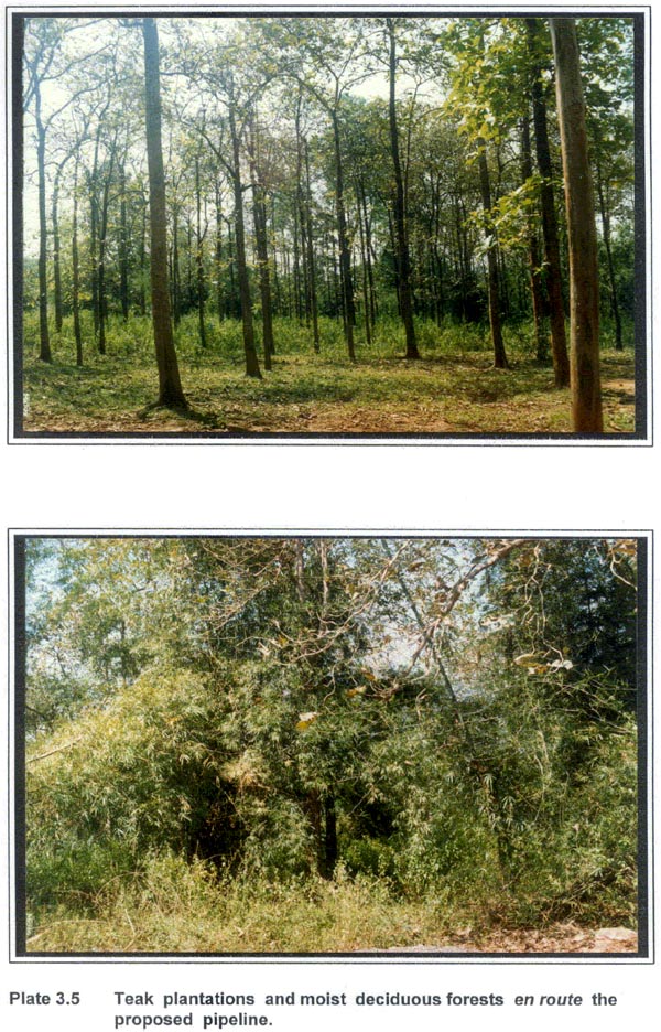
In the teak bearing forests Tectona grandis is the most characteristic species. In the top canopy it is generally associated with Terminalia spp., Pterocarpus spp., Lagerstroemia spp., Adina sp., Dalbergia latifolia, Xylia xylocarpa, Careya arborea, etc.
The species composition of Southern moist mixed deciduous forest include species like Terminalia tomentosa, Albizzia procera, Xylia xylocarpa, Grewia tiliaefolia, in the upper canopy and species such as Careya arborea, Dillenia pentagyna, Cassia fistula, etc. in the middle canopy.
The historical records of these forests (George, 1963) suggests that Reserved Forest patches in Trichur division have been affected by the cyclone of 1940 and their large clearances for temporary food cultivation. As a result, most forested areas in Kerala now remain confined to hilly areas. The few forest patches that exists on gentle slopes and plain areas have been generally converted to plantations. RF I, II and III together constitute a very small area of natural forest that are fairly degraded on account of human interspersions and extraction of plant material for the production of Ayurvedic medicines. Other factor that has resulted in their further degradation is proximity of these forests to road. Attur Reserved Forest (RF IV) of Machad range near Ottupara is the only sizable patch of forest which is likely to be impacted upon by the 1.5 km route of the proposed CCKT Pipeline aligned through it. The results of the ecological investigation of this forest area are presented below:
3.2.1 Attur Reserved Forest (RF IV)
The overall terrain of the forest area is relatively uneven with low hills. This forest area, in its southern side, is contiguous with the large patch of forest area which extends upto the Kombazha and Vaniyampara near Peechi. The proposed pipeline route passes through the forests on the lower slopes of Akamala hills. On the basis of the vegetation composition, this forest has been categorised under 3B/C2 type - Southern moist mixed deciduous forest type (Champion and Seth, 1968). A detailed phytosociological study of this forest area has been conducted by KFRI (Menon and Balasubramanyan, 1985). According to this study, the area predominantly shows the association of Xylia xylocarpa-Grewia tiliaefolia-Dillenia pentagyna-Acacia intsia. The other important species of this forest area are Lagerstroemia microcarpa, Sterculia urens, Lannea coromandelica, Dillenia pentagyna and Bombax malabaricum in the upper canopy. The middle canopy tree species include Grewia tiliaefolia, Wrightia tinctoria, Xylia xylocarpa. The phytosociological analysis of RF IV is presented in Table 3.3.
Table 3.3 Phytosociological analysis of Attur Reserved Forest (RF IV) (Menon and Balasubramanyan, 1985)
| Name of the species |
Average Girth |
% Freq. |
Basal Area |
Relative Density |
Relative Frequency |
Relative Basal Area |
IVI |
| Dillenia pentagyna |
65 |
60 |
336.36 |
7.69 |
10.00 |
12.41 |
31.10 |
| Acacia intsia |
15 |
60 |
17.93 |
7.69 |
10.00 |
0.66 |
18.35 |
| Bridelia squamosa |
40 |
20 |
127.42 |
2.20 |
3.33 |
4.70 |
10.23 |
| Xylia xylocarpa |
55 |
90 |
240.96 |
16.48 |
15.00 |
8.89 |
40.37 |
| Lagerstroemia microcarpa |
65 |
70 |
336.36 |
9.89 |
11.67 |
12.41 |
33.97 |
| Helicteres isora |
15 |
80 |
17.93 |
24.18 |
13.33 |
0.66 |
38.17 |
| Wrightia tinctoria |
25 |
50 |
49.74 |
6.59 |
8.33 |
1.83 |
16.72 |
| Holarrhena antidysenterica |
20 |
40 |
31.75 |
4.40 |
6.67 |
1.17 |
12.24 |
| Sterculia urens |
95 |
10 |
718.81 |
1.10 |
1.67 |
26.51 |
29.28 |
| Grewia tiliaefolia |
65 |
80 |
336.36 |
15.38 |
13.33 |
12.41 |
41.15 |
| Lannea coromandelica |
45 |
20 |
161.43 |
3.20 |
3.33 |
5.95 |
11.48 |
| Bombax malabaricum |
65 |
20 |
336.36 |
2.20 |
3.33 |
12.41 |
17.94 |
Based on visual interpretation of 1:50,000 scale false colour composites (FCCs) of IRS LISS-IIB satellite data, Shri A.R.R Menon of Kerala Forest Research Institute (KFRI), Peechi, prepared a vegetation map of the entire Trichur forest division and classified this forest as Moist Deciduous class I (i.e. with < 30% cover class). Low maturity and continuum indices in this forest area (Table 3.3) can be attributed to the high level of biotic pressures which interfere with the natural succession pattern of the vegetation of the area (Menon and Balasubramanyan, 1985).
Wildlife values
No direct or indirect evidences of mammalian wildlife species were recorded from these forests. The only reptilian species recorded was a Rat snake. Loss of forest contiguity on account of South - Western Railway Line, National Highway 47 and extensive clearing for plantations has greatly reduced the potential of this forest as terrestrial wildlife habitat. The multi storied structure of forest however, support diverse avifaunal species. Some of the common species reported are Lesser goldenbacked woodpecker (Dinopium bengalensis), Small minivet (Periocrocotus cinnamomeus), Tailor bird (Orthotomus sutorius), Indian robin (Saxicoloides fulicata), Common wood shrike (Tephrodornis pondicerianus), Black drongo (Dicrurus adsimillis), Jungle babbler (Turdoides straitus), Common iora (Aegithina tiphia), Indian treepie (Dendrocitta vagabunda) and Small green bea-eater (Merops orientalis).
|


