|
The relevance of ecological assessments for environmental appraisal of development projects is established globally (Bagri & Vorhies, 1997; UNEP, 2000). The outputs of such assessments provide robust information base on ecological features of the area that can provide scientifically defensible rationale for good environmental decision making.
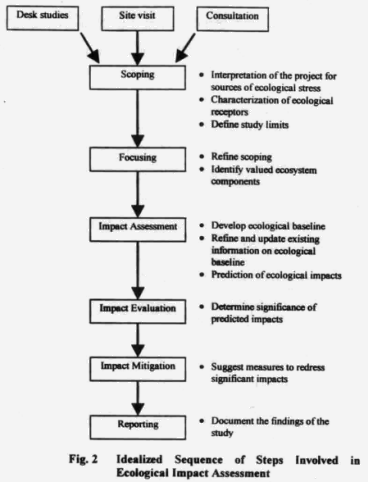
The methodological approach adopted for this study conforms to the standard practices followed worldwide in the evaluation of such developmental projects (Bagri & Vorhies, 1997; Petts, 1999; Treweek, 1999). A broad framework of the procedure followed for the study is illustrated in Box 2.
2.1 Desk studies
The earlier prepared Environmental Impact Assessment report (Anon., 2001) provided by the Vidarbha Irrigation Development Corporation (VIDC), Maharashtra State on the proposed Human River Project was an important source of documentation on the Project. Prior to the field visit, the areas of conservation and developmental interest of the proposed Project were identified and marked on a 1:50,000 Survey of India Topo-sheets for identifying sites for field observations. The spatial information with respect to the following thematic layers: - (a) the total Project area, (b) the area under submergence of the proposed Project, (c) village locations within the submergence and additional areas under the Project, (d) forest cover under the Project area, (e) the riparian zone within the Project area, (f) the route alignment of the proposed canals and (g) the location of the Protected Area (National Park, Sanctuary and Tiger Reserve) and Reserved and Protected Forests within 5 km radius of the Project area was brought on to a single composite map. The remotely sensed data of the Project area were an additional source of information for validating and supplementing the spatial information, wherever necessary.
2.2 Consultations
Prior to initiating the field studies to accomplish the tasks mandated for rapid ecological assessment, detailed consultations were held with the officials of the Vidarbha Irrigation Development Corporation and the senior officials of the Maharashtra State Forest Department on 22nd December, 2002 in the offices of the Superintendent Engineer, Vidharba Irrigation Department and the Principal Chief Conservator of Forest, Maharashtra Forest Department, at Nagpur. Interactions with Project authorities and resource managers provided the much-needed technical information on Project design, and improved our understanding for better visualization of the range of activities proposed under construction and implementation phases of the Project and the ecological information critical for prioritization and delineation of thrust areas and nature of threats. Consultations with Director General of Forests & Special Secretary to Govt. of India, Ministry of Environment and Forests and Director, Project Tiger & Inspector General of Forests, Ministry of Environment and Forests, Govt. of India were also made subsequent to field Studies. The list of persons met is given in Annexure IV.
2.3 Site visit for delineating thrust areas and scoping
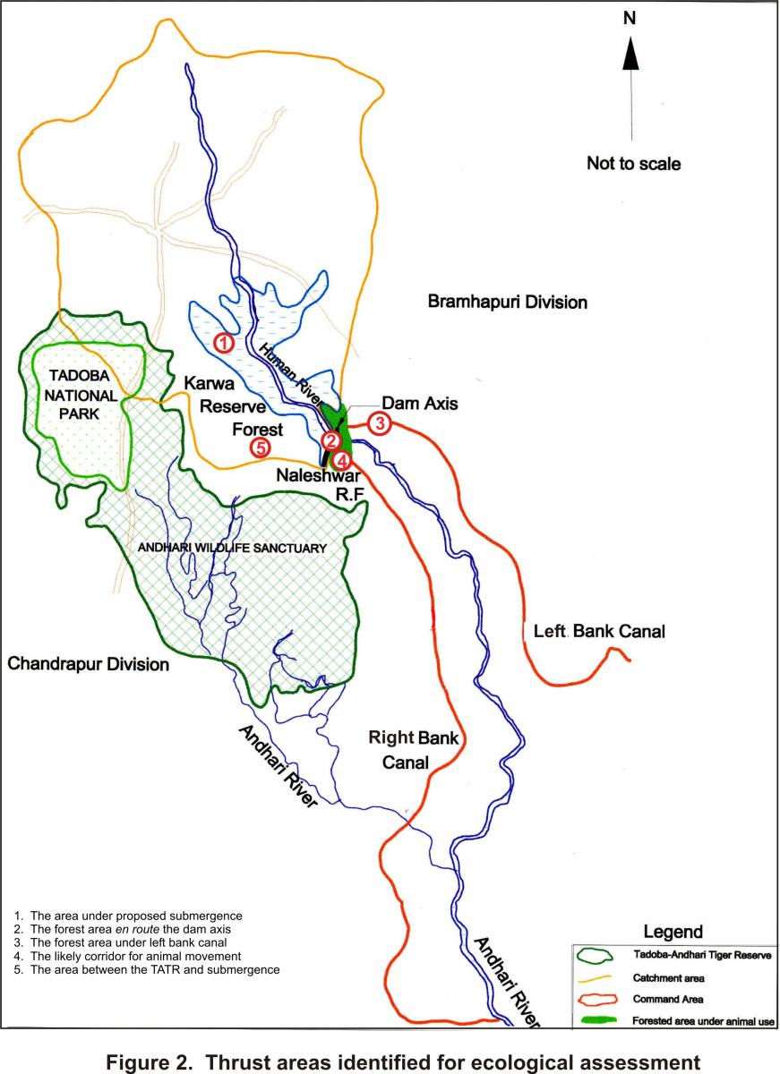
An initial reconnaissance within a 5 km radial distance of the Project area was undertaken for familiarization with existing land use patterns and areas of ecological interest. Based on the spatial features, extent of forest areas delineated for diversion and clear felling under Project and the perception of threats to wildlife conservation, the following five thrust areas were identified for conducting ecological assessment (Table 5 & Figure 2).

Figure 2
Table 5. Thrust areas identified for ecological assessment.
| Sl. No. |
Thrust areas identified |
Location |
Reference point on Figure 2 |
Rationale |
| 1. |
The area under proposed submergence |
Karwa Reserved Forest |
1 |
The diversion of forest land for submergence, tree felling and the creation of a large reservoir (wetland) may alter the wildlife use and present biodiversity values of the area. |
| 2. |
The forest area en-route the dam axis |
Reserved Forest Compartment No. 232 of Chandrapur Forest division |
2 |
The proximity of Reserved Forest through which the proposed earthen dam axis is oriented to Tadoba-Andhari Tiger Reserve (TATR) is likely to alter quality and size of the habitat and animal use. |
| 3. |
The forest area under left bank canal |
Reserved Forest Compartment No. 232 of Chandrapur Forest division |
3 |
The initial linear section of 1.5 km of Left Bank Canal (LBC) that traverses through Reserved Forest is likely to result in habitat degradation, destruction, and consequent reduction in use by animal and disruption of their movement. |
| 4. |
The downstream corridor for animal movement |
Reserved Forest Compartment No. 232 of Chandrapur, 47 & 48 of Bramhapuri Forest division |
4 |
The creation of the dam is likely to result in fragmentation of the population of large and wide-ranging animals in Compartment No. 232, which is presently recognized as a possible conduit for animal movement between Shioni Range (Chandrapur Division) and Nagbhid Range (Bramhapuri Division). |
| 5. |
The area between the TATR and submergence |
Reserved Forest Compartments No. 232, 234, 262, & 258 of Chandrapur Forest division |
5 |
The creation of the reservoir may affect animal movements in the Reserved Forest between the boundary of TATR and the proposed reservoir, which acts as a possible conduit for animal movement towards the Bramhapuri Forest Division. |
2.4 Methods for developing ecological baseline
Given the brief of WII’s task, the primary focus was restricted to the assessment of existing use of the area by wild animals and a broad assessment of the status of wildlife habitats and their biodiversity values. While the survey and inventory of all forms of life is desirable to determine use by animals and to document the biodiversity of an area, it is not always practically feasible to include all forms of life within the short time frame in which outputs of ecological assessments are required, as the environmental appraisal of Projects for environmental clearance are time bound. In any case, the wide ranging wild animals are essentially the major group likely to be affected due to possibility of habitat fragmentation. Of the many approaches available to assess the biodiversity and use of an area by wild animals, a rapid assessment approach of producing a species list with emphasis on recording endangered species was adopted (Sutherland, 2000). Efforts were made to document the presence and use of large carnivores (top-level predators with large home-ranges), prey species and additionally efforts were also made to document birds and reptiles. Mammal species (in particular carnivores) are elusive and direct sightings are not possible. In such situations, the presence of animals in the area was established using a combination of direct (sightings) and indirect evidences (pugmarks, scats, kills) (Table 6). We also relied on opportunistic searches to record the presence of other taxa of interest.
Table 6. Summary of field techniques to establish animal presence.
| Techniques |
Target taxa |
| Direct evidences |
| Transects |
Ungulates, primates, & birds |
| Opportunistic |
Ungulates, primates, birds & reptiles |
| In-direct evidences |
| Pugmarks & Hoof marks |
Large cats, small cats, civets, ungulates & other mammals |
| Scats & droppings |
Large cats, civets, ungulates, sloth bear, & small mammals |
| Others |
| Burrows & digging |
Monitor lizards, mammals |
| Calls & feathers |
Birds |
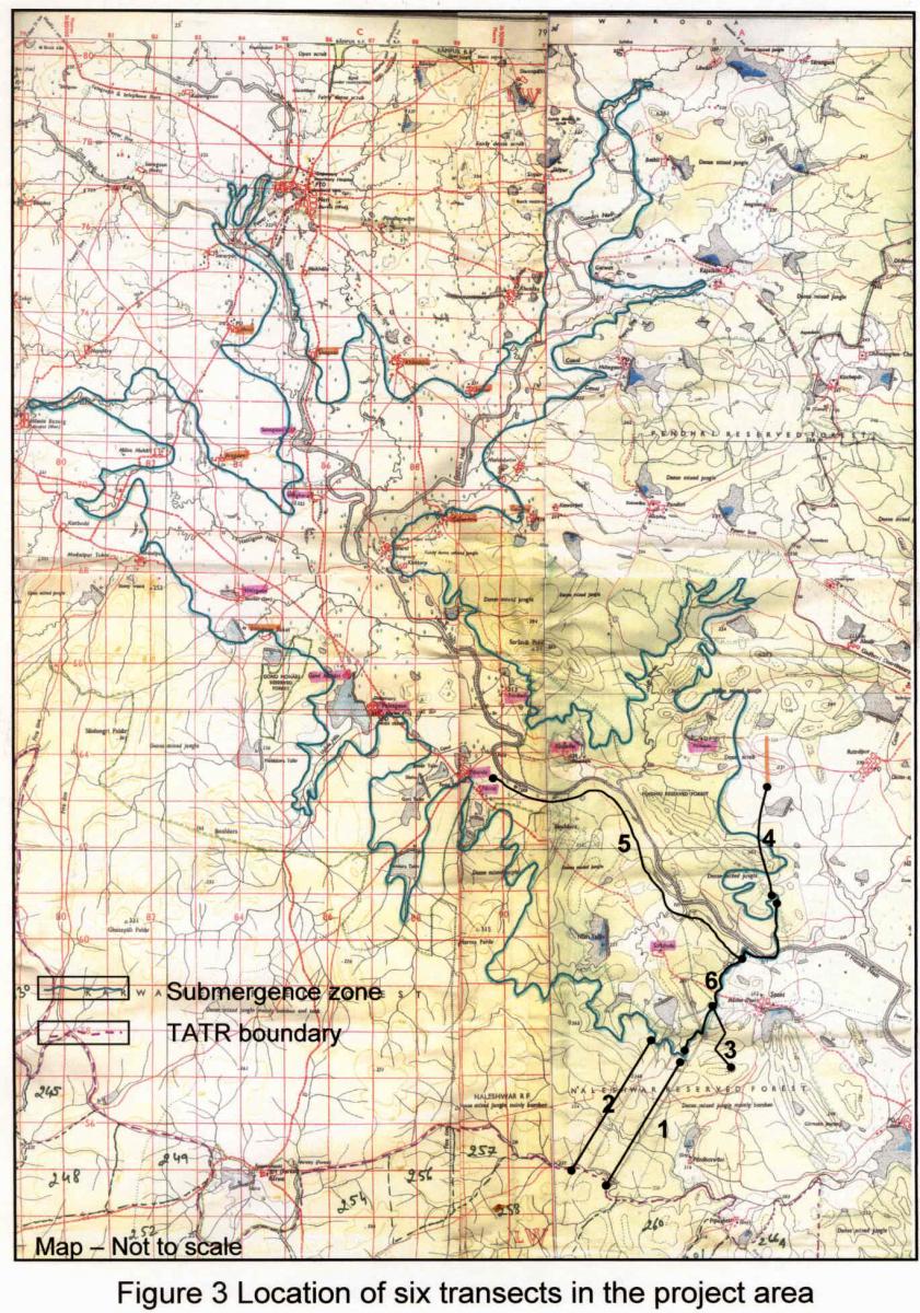
We used transects of variable lengths in the areas of ecological interests (Table 7 & Figure 3) and recorded all direct and indirect evidences on transects. GPS locations were taken at the start and the end points of each transect and for a majority of the locations with animal evidences. The total distance of each transect was calculated using GPS. The transects were aligned in a linear fashion and some were curvilinear.
Table 7. Transect locations in the Project area, their lengths and GPS bearings.
| Transect No. |
Compartment number (s) surveyed |
GPS bearings |
Location of the transect |
Transect length (straight distance) |
| Transect # 1 |
232, 234, 262, 258 |
79 31' 36.90 N
20 18' 00.96 E
79 30' 26.95 N
20 16' 14.47 E
|
Proposed dam site (end point 3360 m) to the TATR boundary (Pillar 872) |
3.87 km |
| Transect #2. |
258, 262, 234, 232 |
79 30' 20.29 N
20 16' 14.51 E
79 31' 24.75 N
20 18' 01.28 E |
TATR boundary (Pillar 868) to the end of the proposed dam site (the end point) |
3.79 km |
| Transect #3. |
232 |
79 32' 19.83 N
20 19' 12.761E |
From the 270 m mark on the dam site (the take off point of the left bank canal) till the point that the canal comes out of the forest) |
1.5 km |
| Transect #4. |
47, 48 |
79 32' 17.11 N
20 20' 12.43 E
79 32' 23.77 N
20 19' 20.58 E |
From the old bund to the 0 point of the dam |
1.61 km |
| Transect #5. |
- |
79 29' 11.17 N
20 21' 10.37 E
79 32' 11.60 N
20 19' 01.87 E |
Started from Paarna village and walked along the west bank of Human river till the dam site |
6.57 km |
| Transect #6. |
The Dam axis |
79 32' 23.77N
20 19' 20.58 E
79 31' 36.90 N
20 18' 00.96 E |
From 0 m – 3360 m milestone of the dam axis |
3.2 km
|
2.5 Visit to the Naleshwar Dam
Conscious of the need to develop an understanding of the post- Project scenario of the Human River Project, the WII team undertook a site visit of the Naleshwar dam (built in 1914). This was undertaken with an objective to visualize the magnitude of infrastructure development associated with irrigation Projects, nature of activities in the implementation phase of a functional irrigation Project and gather perception of the likely impacts of the Project activities on the ecology of the area. Consideration of the post-Project scenario of the Naleshwar dam is also strongly justified on the premise that the proposed canal (Right Bank Canal) under the Human irrigation Project is located in the same landscape and a section of it would be aligned within the existing right of use of the canal originating from the head of the Naleshwar dam.

Figure 3
|


