|
Mitigation essentially includes any deliberate action taken to alleviate adverse effects, whether by controlling the source of impacts or the exposure of the ecological receptors to them (Treweek, 1999). Though the need for ecological mitigation is widely acknowledged it should clearly be borne in mind that ecological solution to engineered modifications of natural areas can never be complete and perfect for arresting all ecological impacts.
Although, the best form of mitigation is certainly avoidance of impacts through design, this may not always be feasible under the given technological and design constraints and the limited financial resources for planning ecological mitigation. The success of mitigation measures would greatly depend on the scale of development and the nature of impacts.
If the objective of mitigation is to help safeguard resources to ensure that development is compatible with conservation goals, it is important for mitigation measures to generally incorporate strategies to ensuring rescue (relocation and translocation), repair, reinstatement, restoration and compensation of ecological receptors and resources.
5.1 Mitigation of impacts due to Left Bank Canal
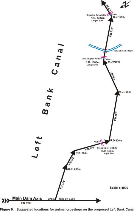
As outlined in section 4.4, the most significant impact of the Left Bank Canal (LBC) is the bisection of the forested habitat in Compartment No. 232 leading to likely disruption in habitat use and ranging of wild animals. Baseline studies indicate that the area is used by a variety of ungulate species. To ensure the contiguity of habitat use by animals, construction of crossing points on the canal is crucial. Based on the observed frequency of animal movement (determined through animal evidences), three locations on the LBC viz. R.D 450 m, R.D 980 m, and R.D 1230 m are proposed for construction of cross ways. These cross over points should be 20 m in length and 35 m in width, (the width based on the proposed width of the LBC) and at these points the LBC would go underground. Once the LBC has been constructed, habitat restoration works would have to be undertaken at the cross over points to make these sites comparable with the adjoining forest habitat. Creation of `waterholes’ near the cross over points would have an added advantage in ‘routing’ and facilitating their movement. The waterholes could be maintained through gravity operated systems drawing water from the LBC. In order to minimize the construction phase impacts, the construction of the LBC through the forest would have to be ensured within the shortest possible time. The tentative location of water points for wild animals across LBC are shown in Figure 9.
5.2 Maintenance of animal movements across downstream corridor
As outlined in section 4.3, the Reserved Forest Compartments Nos. 232 and 47, which form the downstream corridor, are very critical for movement of wild animals especially the tiger. The baseline information has indicated extensive use of these compartments for movement between and to adjoining forest areas. The Project would bring about reduction in the present area (227.43 ha) by 126.43 ha and in the area of Compartment No. 47 by 112.94 ha. To offset this loss of area it is proposed that (a) the legal status of Sirkada P.F. (279.58 ha), Sirkada Zudpi (81.07 ha) and Sioni P.F. (107.99 ha) which form the fringes of compartment Nos. 232 & 47 first be upgraded from Protected Forest to the status of Reserved Forest and then promote habitat restoration measures (afforestation & assisted natural regeneration) along with enforcement of measures to control biotic pressures such as practice of livestock grazing, illicit felling of trees, collection of fuel wood and setting fires. These measures would lead to recovery of habitat quality and ensure the corridor values across these compartments.

Figure 9
5.3 Enhancing habitat availability in post-Project scenario
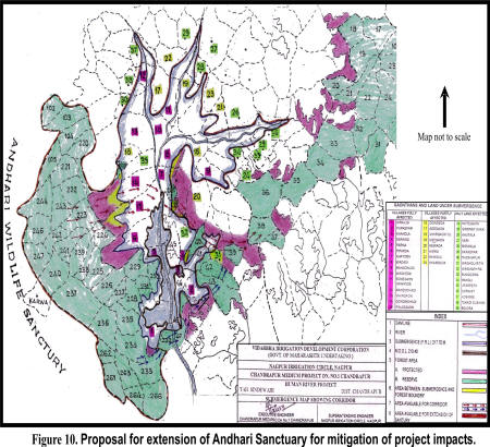
It is evident that the proposed Project will lead to a loss of 1925.55 ha of forest land due to submergence and other associated uses. In addition to this, the Project will necessitate rehabilitation of 23 villages from the Project area between the western boundary of TATR (formed by Andhari Wildlife Sanctuary) and the proposed submergence area. This area, which presently is a mix of habitations and agriculture fields, is used by wild animals across Andhari Wildlife Sanctuary towards the Human river as a habitat continuum. In order to enhance quality and availability of habitat in the post Project scenario it is proposed that the area lying between the periphery of Andhari Wildlife Sanctuary and the proposed submergence area comprising Karwa Reserved Forest Compartments, adjoining Protected Forest Areas, evacuated villages and draw down areas be upgraded into a Wildlife Sanctuary and designated as Andhari Wildlife Sanctuary Extension. This proposal would benefit conservation of wildlife in the following ways (i) it would amend the present administrative boundary of Andhari Wildlife Sanctuary to a more natural ecological boundary by including the submergence and draw down areas, (ii) the area would also serve as an additional ‘upstream corridor’ for animal movement especially tiger from the Chandrapur Forest Division to Bramhapuri Forest Division, (iii) it would prevent any cultivation of the draw down area, which would become an illegal operation in a Wildlife Sanctuary, and (iv) the creation of wetland on account of submergence would benefit several species of waterfowl already recorded elsewhere in the districts of Chandrapur and Bramhapuri. The creation of new avian habitats by the reservoir assume some importance for water bird conservation at a time when waterfowl habitats in many parts of the country are being reduced due to extensive drainage of wetlands. It is also proposed that during the clear felling operations, some tall and well branched be retained to provide sites for nesting and roosting of avifaunal species to facilitate the use of habitat created by impoundment of water after submergence. The areas to be included in the proposed Andhari Wildlife Sanctuary Extension are given in Table 12 a & b and shown in Figure 10.
Table 12. Areas* to be included in the proposed Andhari Wildlife Sanctuary Extension.
12a. Reserved Forest
| Sl. No. |
Category |
Compartment Nos. |
| 1. |
Karwa Reserve Forest |
102, 103, 104, 105, 220, 221, 222, 223, 224, 225, 226, 227, 228, 229, 230, 231, 232, 233, 234, 235, 236,
237, 238, 239, 240, 241, 242, 243, 244, 246, 247, 261, 262, 263, 264, 266 |
12b. Village areas including private and to acquired by the Project authorities and village PF that would form part of the extension plan.
| Village No. |
Name of village |
Total area (ha) |
Area under submergence
(ha) |
Area between submergence and forest boundary
|
| Private Land (ha) |
Protected Forest (ha) |
Total area (ha) |
| 15 |
Palasgaon |
901 |
431 |
188 |
282 |
470 |
| 14 |
Gondmohadi |
522 |
175 |
104.1 |
242.9 |
347 |
| 39 |
Belora |
77 |
71.08 |
5092 |
0 |
5.92 |
| 8 |
Wadsi |
241 |
164 |
46.2 |
30.8 |
77 |
| 7 |
Khatoda |
253 |
201 |
36.4 |
15.6 |
52 |
| 33 |
Bungizora |
69 |
9.9 |
17.73 |
41.37 |
59.1 |
| 32 |
Wasan Vihira |
64 |
58.83 |
1.55 |
3.62 |
5.17 |
| 4 |
Sarandi |
171 |
122 |
19.6 |
29.4 |
49 |
| 31 |
Wagholi |
104.36 |
8.47 |
67.13 |
28.76 |
95.89 |
| Total |
|
2402.36 |
1241.28 |
486.63 |
674.45 |
1161.08 |
*A proper boundary survey and demarcation would have to be undertaken jointly by the Project authorities and the Maharashtra Forest Department to precisely determine the area of the proposed Andhari Wildlife Sanctuary Extension.
5.4 Rehabilitation of Karwa village
The proposed Project will lead to rehabilitation of 23 villages coming under total and partial submergence. The Project authorities have worked out the rehabilitation plan along with a budgetary provision. However, in the post Project scenario one village KARWA, located on the fringe of TATR would still remain as an enclave as it is not affected by the proposed Project and therefore not included in the rehabilitation package. The residents of Karwa village have expressed their desire to be re-located as they apprehend that in the post-Project scenario they would be deprived of the developmental inputs including access and would be practically isolated. It is therefore proposed that a rehabilitating package may also be developed for Karwa village by the Project authorities and integrate it fully in their responsibilities. The relocation would lead to disturbance free habitat for the wild animals in and around TATR, besides providing justice to the residents of Karwa village.

Figure 10
5.5 Construction management and monitoring
One of the facets of mitigation planning that is often been neglected in may developmental Project is on-site environmental management during the construction phase, the time when environmental damage actually occurs. Interestingly, this phase is one where Project authorities exert little control, as the work is generally contacted to a construction company, which may not always respect the agreed upon mitigation measures. To address this situation it is proposed that an Environmental Monitoring Cell to monitor the activities of contractors and to resolve any operational problems, which might threaten the ecological concerns of the area be established and unambiguously mandated for the purpose. It is also proposed that for ensuring effective compliance of the suggested mitigation measures, they should be included in the contract specifications and monitored periodically by the Environmental Monitoring Cell.
5.6 Strengthening wildlife conservation in TATR region
The location of the proposed Project within the vicinity of the TATR is likely to affect its current infrastructure as some of the forest nakas may need to be relocated. The proposed Andhari Wildlife Sanctuary Extension, coming into existence would require wildlife management inputs in terms of habitat management and protection. Habitat recovery strategies in the catchment area and strengthening of physical infrastructure would be needed. It is learnt that a Wildlife Conservation Plan with financial implications has been prepared by the Wildlife Wing, Maharashtra State. This plan needs to be funded by the Project Authorities to ensure that wildlife conservation in the TATR and its surrounds gains significantly from the project rather than surrendering any advantages.
|


