Baseline Status
|
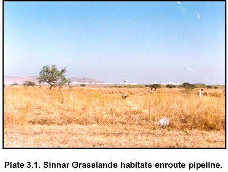
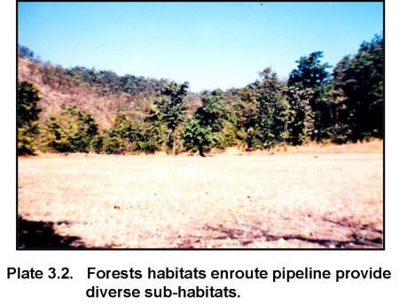
Collection of baseline information on flora and fauna through selected attributes before the initiation of the project is an essential step in EIA study. The purpose of the baseline studies is to describe the ecological conditions of the area under investigation without the development having proceeded. Prediction of the impacts associated with the construction, operation and post operational phases of the proposed development can be based on the changes or deviations that would occur in biological characteristics of the area already measured through baseline studies. Baseline studies usually consist of a combination of desk studies, field survey and data analysis. Baseline status of wildlife values both floral and faunal have been presented in this section of the report. The dimension (spatial and/or temporal) of anticipated impacts of the proposed pipeline would be largely determined on the basis of probable changes more specifically, in the population of terrestrial and aquatic fauna and the habitat characteristics of forests, grasslands (Plate 3.1 & 3.2) and wetlands en route the Bombay-Manmad Pipeline Project.
3.1 STATUS OF FORESTS
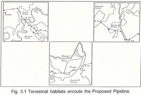
I. Tectona grandis (Teak), Terminalia tomentosa (Ain), Wrightia tinctoria (Kuda) and Ficus asperrima (Karavanti). II. Tectona grandis (Teak), Acacia catechu (Khair), Wrightia tinctoria (Kuda) and Cassia tora (Takla). III. Tectona grandis (Teak), Anogeissus latifolia (Dhavada), Wrightia tinctoria (Kuda) and Cassia tora (Takla). IV. Terminalia tomentosa (Ain), Acacia catechu (Khair), Schleichera oleosa (Kusumb) and Carissa carandas (Karvand). V. Garuga pinnata (Kakad), Lannea coromandellica (Shemat), Wrightia tinctoria (Kuda), and Cassia tora (Takla). VI. Terminalia tomentosa (Ain) and Lagerstroemia parviflora 3.1.1 Jerandi Forest A total of 133 trees belonging to 26 species were enumerated in the sample plots during the vegetation survey. It is evident from the relative densities of tree species (Table 3.1) that Terminalia tomentosa (24.81), Tectona grandis (9.77), Adina cordifolia (7.52) and Mitragyna parvifolia (5.26) are the dominant species of the top canopy layer of this sub-habitat type. Table 3.1 List of tree species recorded from Jerandi Forest along with Relative Density (RD) Values
Other characteristic tree species recorded in the middle canopy layer are Schleichera oleosa, Derris pinnata, Mangifera indica and Careya arborea. Although, Bambusa arundinacea and Dendrocalamus strictus are listed in the middle canopy association (Working Plan, 1988 - 1989), these were not observed in the sample plots during the survey. It could be possible that the two species not observed during survey would have dried after gregarious flowering (Working Plan, 1988-89). Shrub layer of the Jerandi Forest is mostly dominated by Carissa carandas. Percentage of shrub and grass cover recorded in this area is given in Table 3.2. Table 3.2 Percentage of shrub and grass cover of Jerandi Forest
Percentage (Scores) : 0 (0), 1-25 (1), 25-50 (2), 50-75 (3), 75-100 (4) Bhatsai River is the major source of water. The water was confined to small pools during the study period. This river generally has a depth of 5 m during the rainy season. Fauna
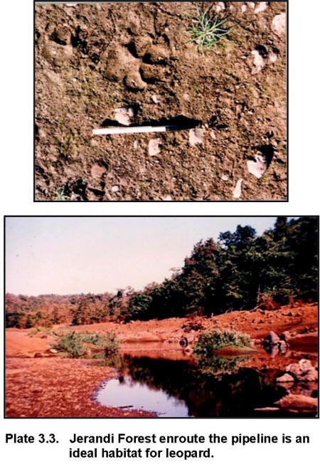
Few direct and indirect evidences were collected during the survey. These include shells of turtle and hair of wild pig from the collections of local villagers and the pugmarks of leopard and hyaena along the riparian stretches in the forest (Plate 3.3). Presence of leopard has been further confirmed from the records of cattle lifting by wild animals. Incidences of predation of cattle by wild animals when the domestic cattle were released inside the forest for free grazing were also reported by large number of local people living in and around the Jerandi Forest. In addition to large and small mammals, a chelonian species was also reported (Indian Flap Shell Turtle).
Being ecologically diverse, bird communities are good index for monitoring environmental changes (Jarvinen and Vaisanen, 1979). Most of the bird species have relatively short generation time, consequently they are likely to show quick responses to environmental changes (Steel, et al., 1984). This forest area also supports diverse avifauna. In total, 67 species of birds belonging to 32 families have been recorded during the intensive surveys (Table 3.3).
Cutting of trees for fire wood and timber, lopping of tree species for fodder, cattle grazing and illegal cultivation are some of the existing biotic pressures operating within the forest. Of the 26 tree species recorded from the vegetation plots, seven species were cut for fuel wood and timber and five species were lopped for fodder. Overall, percentages of cutting and lopping were 30.95% and 36.83% respectively (Table 3.4). Sighting of a wild pig killed by local villagers and a clump of bird feathers are some of the evidences collected during the survey to provide substantial indications of existing pressures on animals and bird species for meat in this area. Observations on the number of villagers engaged in wood removal from forest and presence of cattle and cattle dung in the sample plots were also made. Table 3.3 List of bird species recorded from Jerandi Forest
Table 3.4 Evaluation of tree cutting and lopping pressures in Jerandi Forest
3.1.2 Phugala Forest Total number of tree species and their numbers recorded in the sample areas is 16 (species) and 229 (trees) respectively. Terminalia tomentosa (RD-29.69) and Lagerstroemia parvifolia (RD-26.64) are the two dominant species which are characteristic associations of the sub-habitat/forest type of VI (Ain-Bonda association) of this forest habitat. According to the Working Plan (1988-89) of Thane Forest Division, this association is mostly found in Tokawada and Washala Ranges in the foothills of Western Ghats. The other underwood species are not very well defined. The species recorded from the middle layer of the forest are given in the Table 3.5. Ground cover is generally sparse. An average of 32.50% of shrub and 57.50% of grass cover have been recorded in the sample plots (Table 3.6). Average vegetation height of this forest ranges from 5 to 10 m. Table 3.5 List of tree species recorded from Phugala Forest along with Relative Density (RD) Values
Percentage (Scores) : 0 (0), 1-25 (1), 25-50 (2), 50-75 (3), 75-100 (4) Fauna Avifaunal studies provided a list of 13 bird species (Table 3.7) from Phugala Forest. All these are common birds that do not require very specialised habitats. Table 3.7 List of bird species recorded from Phugala Forest
Table 3.8 Evaluation of tree cutting and lopping pressures in Phugala Forest
The reserved forest of West Nashik Forest Division near Sinnar is different from the forest areas of Shahapur Division in that they have different edaphic features (soil depth ranging from 0.3 to 1 m) that support grassland community. These grasslands are heavily overgrazed and have pronounced xerophytic ecological conditions, reflected in large number of xerophytic species of flora in the area. The growing stock of most species was very stunted (< 6 m) and malformed. Patches devoid of grasses interspersed with some rocky outcrops were common. The general floristics of this area is as under: Top canopy: Not available Second canopy: Mostly dominated by Terminalia tomentosa Shrub layer:Acacia leucophloea, Carissa carandas, Lantana camera, Zizyphus mauritiana, Euphorbia neriifolia and Opuntea stricta Common grass species found in this areas are Heteropogon contortus, Dichanthium annulatum, Andropogon pumilus, A. schoenanthus, Cymbopogon martinii, Themeda quadrivalvis and Apluda mutica. 3.2.1 Sinnar Grassland The length of the proposed pipeline route passing through the grassland near Sinnar is 0.95 km. Since, it is the only representative of grassland habitat en route the proposed pipeline, it was selected for intensive study. Total area of the grassland is 3 ha., of which 31.66 % (0.95 ha.) area is under RoW. In total, seven grass species have been recorded from the grasslands. The height of the grass species varies from 5 cm. to 167 cm. (Table 3.9). The Maharashtra Forest Department earns a revenue of about Rs. 16,000/- per year from the harvest of grass species from this grassland. Table 3.9 List of grass species recorded from Sinnar Grassland
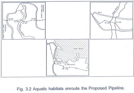
During the intensive study, not many evidences of faunal species could be collected. Several factors have led to the reduction of the habitat potential of this grassland habitat. More significant of these factors are i) its proximity to the road, ii) its small size and iii) regular harvesting of grass from this area by Maharashtra Forest Department to generate revenue. 3.3 STATUS OF WETLANDS A wetland is a place that has been wet enough for a long enough time to develop specially adopted vegetation and organisms (Maltby, 1986). Wetland ecologist have now provided strong evidence that wetlands often represent large economic values, although sometimes in an indirect way. They are often much more productive in their natural state than when converted, and they have important effects in reducing flood peaks, maintaining the ground water level and stabilizing the climate. Furthermore, they act as sinks of nutrients and contaminants. Changes associated with their functions (both ecological and economic) as a result of proposed pipeline project needs to be assessed. The proposed pipeline route would cross 11 water bodies, of which except Ulhas Creek and Godavari River, all others are seasonal. The following section presents the baseline status of major wetland habitats (Fig 3.2).
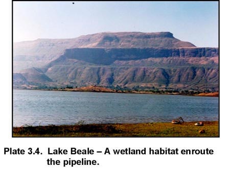
3.3.1 Ulhas Creek The proposed pipeline route would cross Ulhas Creek near Thane. According to the "tidal hydroperiods" this creek comes under the category "subtidal hydroperiod", where the substrate is permanently flooded with tidal water. In this creek the substrate is muddy. The total width of the creek ranges between 450 and 500 m and its depth is approximately 10 m. The adjacent area of the creek is covered with mangroves and provides an excellent estuarine environment. The intensive survey of the creek, did not provide sightings of any significant aquatic faunal species. Few species of birds such as Grey Heron (Ardea cinerea), Little Cormorant (Phalacrocorax niger), Little Egret (Egretta garzetta), Red wattled Lapwing (Vanellus indicus), Indian river Tern (Sterna aurantia) and Black winged Stilt (Himantopus himantopus) were sighted during the survey. The secondary sources provided information on the occurrence of few fish species in the creek - Bombay duck, Anchoviella, Pomfrets, Penaeid prawns and Non-penaeid prawns are a few common species found in this creek. Of the chelonians, only one species of turtle i.e. Indian flap Shell Turtle (Lissemys punctata) has been reported from the creek. Low faunal diversity of the creek could be attributed to several factors. Fishing activities in the creek and the pollution of its waters owing to inflow of effluents from the industrial areas in close proximity to the creek and also the contamination of creek waters by leakage of sewage into it have degraded the quality of this aquatic habitat. 3.3.2 Lake Beale Lake Beale located in Nashik district, is the major man made impoundment that would be impacted by the proposed pipeline. The pipeline route is aligned along its periphery for a length of approximately 2 km (Plate 3.4). Based on the "non-tidal hydro periods" scheme of classification of wetlands, this lake comes under "permanently flooded" category. Here, the water covers the land surface throughout the year in all years. However, in case of Lake Beale during the summer months the water spread decreases in the lake.
The adjacent area of this lake is mostly covered by agricultural fields. The lake was surveyed to collect the information on aquatic fauna. Discussions with local people revealed that the lake has been a potential habitat for winter migrants. However, the number of migratory bird species has declined over the years due to increased disturbances associated with the biotic activities. During the intensive survey, 14 bird species were recorded from this lake (Table 3.10). Few common species of fishes were also reported from the lake. Based on the fish catches obtained by the community engaged in the fishing activity in the lake on a regular basis the fish species were recorded. The size of fishes in the catch varied from 1-4 inches. Only one chelonian species, Indian Flap Shell Turtle (Lissemys punctata) was reported from the lake. Table 3.10 List of bird species recorded from Lake Beale
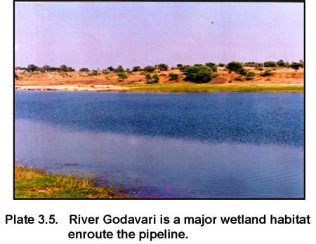
3.3.3 River corridor The only river corridor that would be traversed by the proposed pipeline is the Godavari River Corridor (Plate 3.5). The width of the river is approximately 70 m and the river substrate is mostly rocky.Based on the "non-tidal hydroperiods" category, the Godavari River fall under "intermittently exposed" type of wetland.Here the surface water is present throughout the year except in the years of extreme droughts.
The banks of the river were surveyed on foot for a distance of one km, both upstream and downstream. During the survey, floral and faunal values were evaluated both in the river as well as on the banks. Both the banks are sparsely vegetated, Prosopis juliflora and Acacia nilotica being the dominant species. In the adjacent agricultural fields, the local farmers mostly grow sugarcane. Though Godavari is a perennial river, the stretch of river through which the proposed pipeline would traverse, generally dries up during the summer months because of the construction of a dam upstream of the stretch surveyed. This is not conducive to establishment of distinct flora on the river banks. No direct evidence of aquatic fauna could be collected during the survey. Dialogue with the local fishermen and villagers, confirmed the occurrence of turtles and a few common bird species. During survey, five species of aquatic birds were recorded (Table 3.11). Table 3.11 List of bird species recorded from River Godavari
In addition, to the dam already constructed upstream of the point at which the pipeline traverses the river, illegal pumping of water for irrigation purpose leads to further fluctuations in water level of the river. This is a direct threat to faunal resources of the river. |
|||||||||||||||||||||||||||||||||||||||||||||||||||||||||||||||||||||||||||||||||||||||||||||||||||||||||||||||||||||||||||||||||||||||||||||||||||||||||||||||||||||||||||||||||||||||||||||||||||||||||||||||||||||||||||||||||||||||||||||||||||||||||||||||||||||||||||||||||||||||||||||||||||||||||||||||||||||||||||||||||||||||||||||||||||||||||||||||||||||||||||||||||||||||||||||||||||||||||||||||||||||||||||||||||||||||||||||||||||||||||||||||||||||||||||||||||||||||||||||||||||||||||||||||||||||||||||||||||||||||||||||||||||||||||||||||||||||||||||||||||||||||||||||||||||||||||||||||||||||||||||||||||||||||||||||||||||||||||||||||||||||||||||||||||||||||||||||||||||||||||||||||||||||||||||||||||||||||||||||||||||||||||||||||||||||||||||||||||||||||||||||||||||||||||||||||||||||||||||||||||||||||||||||||||||||||||||||||||||||||||||||||||||||||||||||||||||||||||||||||||||||||||||||||||||||||||||||||||||||||||||||||||||||||||||||||||||||||||||||||||||||||||||||||||||||||||||||||||||||||
Last Updated: October 6, 2015


