|
3.1 Methodological approach for biodiversity inclusive EIA
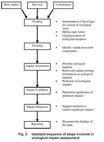
The ecological assessment of the impacts of the proposed pipelin e on the characteristics of biodiversity values and ecological features of the natural systems involve several steps and procedures. The initial steps generally involve a desk study of project related information to enable a careful review of the pipeline route. The rapid site appraisals undertaken subsequently help in identifying site features of ecological interest en route the pipeline. This provides adequate understanding of issues linked to the project to help determine the spatial limits of the study and to ascertain the valued ecological components or the impact receptors that merit focus in an impact assessment study. The subsequent step involves generating an appropriate ecological baseline in a ‘no project’ scenario to aid in realistic prediction and evaluation of future impacts associated with authorisation of projects. e on the characteristics of biodiversity values and ecological features of the natural systems involve several steps and procedures. The initial steps generally involve a desk study of project related information to enable a careful review of the pipeline route. The rapid site appraisals undertaken subsequently help in identifying site features of ecological interest en route the pipeline. This provides adequate understanding of issues linked to the project to help determine the spatial limits of the study and to ascertain the valued ecological components or the impact receptors that merit focus in an impact assessment study. The subsequent step involves generating an appropriate ecological baseline in a ‘no project’ scenario to aid in realistic prediction and evaluation of future impacts associated with authorisation of projects.
The impact assessment methodology also involves development of generalised and project specific approaches and criteria for reviewing least impacting route alternatives; prioritising potentially important biological resources, ecosystem units (or functions) and the river corridors and for evaluating the dimensions and significance of project linked impacts for decision-making with respect to regulating, approving or restricting the proposed development of project as the case may be.
All the steps discussed above are well sequenced in the traditional EIA framework (Fig. 3) that is globally adopted by EIA practitioners with some modifications that are dictated by a country or regional level legislative and procedural requirements for EIA documentation.
3.1.1 Desk studies and consultations
The maps of the various spreads of the proposed pipeline route and the detailed profile of the project provided by the authorities of BPCL were carefully studied. The detailed pipeline route was transferred on corresponding topographical maps (scale 1:50,000) of the area for generating adequate spatial information on the physical and natural features of the pipeline corridor to initiate field studies Extensive literature search provided the much needed insight about the nature of impacts associated with pipeline projects. The secondary sources of information, including the scientific and technical reports, wildlife status survey reports, management plans and working plans of the state forest departments and the census records provided the understanding of floral and faunal values of the area. Discussions with the officials of the state forest departments, scientific and research personnel of academic institutions, naturalist and local people provided additional information on the regional ecology.
3.1.2 Field visit
The rapid site appraisal of the pipeline route between the starting point at Mangalya and the receiving point at Bijwasan was undertaken during early September 2005. The spatial limit for the field studies was confined to 1.5 kilometer wide pipeline corridor. The width of the pipeline corridor for the study was determined based on an understanding of the spatial limits of impact zones of such linear developments as ascertained from literature and from past experiences of conducting assessment of similar linear pipeline projects (WII 1993, 1997, 2001).
The aquatic and terrestrial wildlife habitat area falling under wetlands (river, wetland and reservoirs) and Reserved Forest were identified within the route of pipeline corridor.
For the prioritization of the species and habitats of ecological and conservation interest en route the pipeline, criteria proposed by Treweek (1999) and also adopted in the assessment of the impacts of the earlier laid section of the Mumbai- Manmad Pipeline Extension up to Manglya (WII 2001) was adopted (Box-3.1).
Box 3.1 Criteria for prioritizing potentially important ecosystems or their components
|
High priority
|
Low priority
|
|
Natural or pristine
|
Altered by human activity
|
|
Undisturbed
|
Disturbed
|
|
Large, unfragmented areas
|
Small, highly fragmented areas (unless last remaining examples of habitat or system very rare elsewhere)
|
|
Characteristics (e.g. of a particular tradition of management)
|
Not associated with any particular management tradition
|
|
Unique (e.g. unusual combinations of species or highly localized habitats associated with particular conditions)
|
Commonly occurring
|
|
Ancient
|
Newly created
|
|
Species-rich
|
Species-poor
|
|
Diverse
|
Less diverse (unless low diversity is characteristic of community or habitat)
|
|
Keystone
|
No key role/position or importance for other components
|
|
Rare or restricted in distribution
|
Common or widely distributed
|
|
Declining throughout range
|
Stable throughout range
|
|
Highly specialized
|
Generalist
|
|
Threatened throughout range
|
Not threatened
|
|
Non-resilient (slow to recover)
|
Resilient (quick to recover)
|
|
Irreplaceable (or very slow/expensive/difficult to replace)
|
Replaceable (quick, cheap and easy to replace)
|
|
Poorly understood
|
Well understood
|
Following an initial reconnaissance, a more intensive site visit of the area was undertaken by WII team during September 2005. During the site visit, extensive consultation with project authorities, forest officials, conservation groups, wildlife experts and local communities was done to help improve the visualization of the understanding of project associated activities and their associated impacts on ecological characteristics of the area (refer Annexure III for list of person met).
3.1.3 Evaluation of the route for assessing the ‘least impacting’ alternative
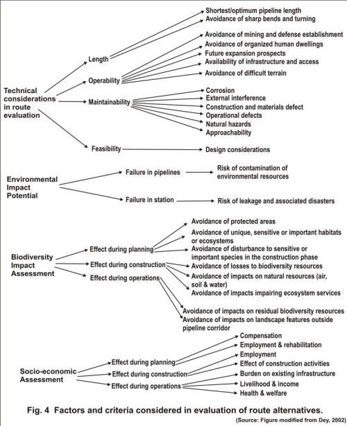
As the global literature on best practices in EIA is growing, one of the essential steps that is being increasingly encouraged in the EIA framework is the evaluation of the project to satisfy the criteria of having adopted ‘least damaging alternative’ from location, design and technology considerations before formulating a detailed proposal for seeking environmental clearance. Accordingly, the proposed route for Manglya- Mathura- Piyala- Bijwasan Pipeline, was evaluated for meeting the ‘least damaging options’ criteria based on the existing guidance (Dey 2002) available for evaluating the pipeline route alternatives ( Fig. 4).

3.1.4 Development of ecological baseline
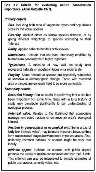
For characterization of areas of ecological interest (forests and wetlands) en route the pipeline, standard methods (Mueller Dombois and Ellenberg1967; Hays et al., 1981)  used for measurement of habitat features and estimating presence and absence of species were followed. Faunal diversity was estimated using the direct and indirect evidences i.e. pellets, droppings, scats and animal tracks etc. within the pipeline corridor. Information on presence absence of different faunal group representative in the area was further substantiated by the information gathered from the local people. For this, pictorial representations of animal species with known distribution in the area was shown to local people to elicit the information about the distribution of species in the area. The information thus received was later validated during the course of field studies. The evaluation of the conservation importance of the forest areas en route was made following the criteria (Box 3.2) suggested by Ratcliffe (1977) and subsequently adopted by several workers (Margules & Usher 1981; Treweek 1999). used for measurement of habitat features and estimating presence and absence of species were followed. Faunal diversity was estimated using the direct and indirect evidences i.e. pellets, droppings, scats and animal tracks etc. within the pipeline corridor. Information on presence absence of different faunal group representative in the area was further substantiated by the information gathered from the local people. For this, pictorial representations of animal species with known distribution in the area was shown to local people to elicit the information about the distribution of species in the area. The information thus received was later validated during the course of field studies. The evaluation of the conservation importance of the forest areas en route was made following the criteria (Box 3.2) suggested by Ratcliffe (1977) and subsequently adopted by several workers (Margules & Usher 1981; Treweek 1999).
Estimation of existing level of biotic pressures (wood cutting, grazing, lopping, hunting etc.) was also made to assess the nature of existing threats to wildlife values of the terrestrial habitats.
Considering that wetlands are a home to a wide variety of aquatic species of birds, amphibian and fishes, their ecological characteristics has been an important consideration in the assessment of impacts of the proposed pipeline. All major rivers and canals were evaluated for their wetland value. River Corridor Survey (RCS) was developed based on the approaches adopted by National Rivers Authority (NRA) 1992. For the purpose of the study, a river corridor included a stretch of river, its banks and the adjacent land within 50 m width.
Hydro-period was considered as the most important parameter that has a significant bearing on the wetland characteristics. The frequency, depth and duration of water’s influence determine to a significant extent the biological values and the functions that the wetland provides (Cowardin et al., 1979; Marvel 1992). Several other parameters that were considered for evaluating the wetland value of the major rivers en route the pipeline are presented in Table 3.1.
Table 3.1 River corridor survey zones.
|
Sections
|
Parameters recorded
|
|
Aquatic
|
Flow and current features (low, moderate and high); physical features; width and depth; substrate type (sandy, muddy, rocky bottom); wildlife values (fishes, amphibians, reptiles, birds and mammals)
|
|
Bank
|
Tree species and other associated plant communities
|
|
Adjacent land
|
Habitat types/landuse
|
|
Existing sources of disturbance
|
Presences of habitation, evidence of use and intensity (eg. collection of resources including fish, water, reeds etc., recreational boating, withdrawal of water for industry, pressures of grazing on bank side and river beds, other existing or proposed developments within the river corridor.
|
3.1.5 Prediction and evaluation of impacts
Prediction of ecological impacts is the most important step in the biodiversity inclusive Environmental Impact Assessment studies. Although scientific approaches and guidance tools are available to predict the impacts of oil and gas development projects on environment (EBI 2005), the approach essentially involves superimposing the (pre-project) ecological baseline over the project related actions to derive the ultimate (post-project) scenario of environmental changes linked to the project in future. While the ecological baseline is developed based on onsite observations and measurement of select ecological /biological parameters, the visualization of project related actions is generally based on the given profile of the project and the experience drawn from earlier implemented projects following similar design and technology.
|


 e on the characteristics of biodiversity values and ecological features of the natural systems involve several steps and procedures. The initial steps generally involve a desk study of project related information to enable a careful review of the pipeline route. The rapid site appraisals undertaken subsequently help in identifying site features of ecological interest en route the pipeline. This provides adequate understanding of issues linked to the project to help determine the spatial limits of the study and to ascertain the valued ecological components or the impact receptors that merit focus in an impact assessment study. The subsequent step involves generating an appropriate ecological baseline in a ‘no project’ scenario to aid in realistic prediction and evaluation of future impacts associated with authorisation of projects.
 used for measurement of habitat features and estimating presence and absence of species were followed. Faunal diversity was estimated using the direct and indirect evidences i.e. pellets, droppings, scats and animal tracks etc. within the pipeline corridor. Information on presence absence of different faunal group representative in the area was further substantiated by the information gathered from the local people. For this, pictorial representations of animal species with known distribution in the area was shown to local people to elicit the information about the distribution of species in the area. The information thus received was later validated during the course of field studies. The evaluation of the conservation importance of the forest areas en route was made following the criteria (Box 3.2) suggested by Ratcliffe (1977) and subsequently adopted by several workers (Margules & Usher 1981; Treweek 1999).


