
Baseline Status
|
4.1 Route specification of the proposed pipeline Table 4.1 Route specification in different spreads of the proposed pipeline.
Although the land use along the entire pipeline in all the five spreads is predominantly cultivation with the pipeline route traversing a total length of 483.3 km of cultivated land, the pipeline route is aligned to traverse linearly through hilly and rocky terrain for 56.0 km, forested tract for 18.64 km, rivers for 2.2 km and other water bodies including canals and reservoirs en route the proposed alignment for 0.2 km (Table 4.2). Table 4.2 Details of pipeline route in its entire stretch between Manglya and Bijwasan.
4.2 Terrestrial and aquatic ecosystems en route the proposed pipeline Based on the information furnished above, it becomes evident that in the entire route stretch between Manglya and Bijwasan, the proposed pipeline will traverse through terrestrial ecosystems confined to patches of forested areas in the route corridor and the aquatic ecosystems falling within the zones of river crossings within the pipeline route corridor. 4.2.1 Terrestrial ecosystems In Madhya Pradesh the proposed pipeline route traverses the forest near Shajapur district for about 142.2 m. This area represents mixed dry deciduous forest type, characterized by sparse vegetation dominated by tree species such as Tectona grandis, Azadirachta indica, Ficus religiosa, Anogiessus latifolia, Dalbergia sisoo and Albizzia lebbek. The shrub vegetation comprised of Cassia auriculata, Calotropis procera and Zizyphus jujuba. The plantations of Acacia Catechu were observed in the pipeline corridor in the Ujjain spread of the pipeline. The conservation values of the area are fairly limited on account of the forest patch being very small and open and accessible by local inhabitants. Of the total length of the proposed pipeline routed through the forested area (18.64 km) in the entire stretch of 740 km, a length of 16.80 km of the pipeline is aligned through stretches of forest falling under forest divisions of Jhalawar, Kota, Bundi, Tonk, and Sawai Madhopur in Rajasthan state (Table 4.3). Table 4.3 Route of proposed pipeline through forested area.
The maximum forest area en route the pipeline route falls in Jhalawar division where the pipeline traverses the forest blocks of Harigarh, Bhagher Baorikheri, Munderi and Bhawrasa Bhagdar for a total length of 12.96 km (Fig. 6). The area is characterized by tropical dry deciduous forest comprising of floral species generally inhabiting dry and arid region and eroded areas. The vegetation comprised of scrub species occupying scattered hills and rocky outcrops. The pipeline route in Bhawrasa Bahgdar and Baori Khera block traverses the miscellaneous forest for about 1.65 km and 1.98 km respectively. In Harigarh block, the pipeline would traverses a distance of 4.0 km through forest blanks with scrub offering very little cover value.
The pipeline traverses the Bagher forest block for a length of 4.8 km. This area represents the part of Reserved Forest and is characterized by dense vegetation on steep and rocky area and is better identified as Chageri hills (Plate 1). The major trees sp. of the area are Butea, Bombax, Anogeissus, Acacia, Buchanania and Boswellia. The shrubs and small trees comprise of species of Grewia, Ziziphus mauritiana, Casearia, Prosopis, Capparis, Woodfordia, Phyllanthus, and Carissa.
The area has a limited habitat value to support species of wild animals found in arid areas on rugged terrain. Although the secondary information sources confirmed the use of the area by species like, chinkara, wild boar, jackal, jungle cat, no records of direct sightings could be collected during the field visit. The forest area is interspersed with habitation and agriculture fields and is heavily impacted by anthropogenic activities. Several evidences of lopping, fuel removal and grazing in the area could be collected during field visit. The pipeline in this area is laid in the valley between the two hills and aligned along an already existing road. The water reservoir located at the base of the Chageri hill (Plate 1), which is the source of water both for human and livestock is located at least 2.0 km away from the pipeline alignment. The forested tracts in Bagher Block offer habitat for Rose ringed and Blossom headed parakeets which are both species of high conservation importance. These species of parakeets occupy open woodland areas on cliffs and hills over looking the Chageri hill. The pipeline corridor in this stretch does not traverse the low lying woodland areas occupied by the parakeets but is aligned at a higher altitude in the valley bottom of the two hills that are at least 30 meter higher in elevation. In the section of the pipeline passing through Kota spread, scrubland interspersed with agricultural fields is a typical feature of this region. The region represents the semi arid condition (Rodgers & Panwar, 1988).The common plants recorded during the survey - Acacia arabica, A.nilotica, Azadirachta indica, Mangifera spp., Ziziphus mauritiana, Butea monosperma, Syzygium cuminii, Prosopis julifera, Prosopis sineraria, Salvadora persica and Acacia spp represent the characteristic species of the open scrub vegetation of this area (Champion & Seth, 1968) The predominant grass species of the area are Cynodon dactylon, Apluda mutica and Imperata cylindrica. In Kota spread, the pipeline traverses 0.6 km of forest area in Sunda Dulhet Block of Bundi Forest Division, adjacent to the bank of the Kalisindh River. The area is fairly open and degraded . The pipeline route through Bundi, Tonk and Sawai Madhopur forest divisions is aligned through small tracts of protected forests that are fairly open and prone to biotic disturbance. The routing through these areas was inevitable to avoid larger and more integrated patches of protected forests and Kualji Closed Area in Bundi Division and Ranthambore Tiger Reserve in the Sawai Madhopur area. The final route alternative proposed for laying the proposed pipeline between Manglya and Bijwasan does not traverse through Protected Areas and sensitive habitats in any of the five spreads. 4.2.2 Aquatic Ecosystem Table 4.4 Major river crossings en route the proposed pipeline.
Other water body en route the proposed pipeline is the Agra canal that would be traversed by the pipeline at two locations in Mathura spread and at one location in the Delhi spread. 4.2.2.1 Characterization of ecological values of major rivers en route the pipeline Shipra river
Kalisindh
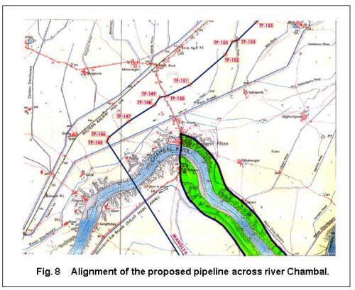
Chambal Approximately 400 km of this river ecosystem, with diverse flora, aquatic life and avifauna is a part of the larger National Chambal Sanctuary covering an area of 5,400 km2 and co-administered by the states of Rajasthan, Madhya Pradesh and Uttar Pradesh. This river sanctuary is a refuge for the rare and endangered Gharial (Gavialis gangeticus) and Gangetic River Dolphin (Platanista gangetica). The 400 km stretch of the river sanctuary that has stretches of sandy ravines also supports Marsh Crocodiles, Smooth Coated Otters, 6 species of Terrapins/Turtles and nearly 250 species of birds many of which are migrants and rare. The pipeline crosses the river Chambal in Kota spread near Gawri village. This location is more than 15 km upstream of the boundary of the Chambal Sanctuary (Fig. 8). Here the river is fairly wide and moderately flowing (Plate 5). The river bed is sandy and the banks are flat. The width of the river at the site of crossing is about 200 m. This river is a home to a wide variety of fishes such as Labeo rohita, Cirrhinus mrigala, Cirrhinus reba, Mystus seenghala, Ompok bimaculatus, Mystus cavasius, M. tengara, M. bleekeri, Wallago attu, Channa punctatus, Rita rita, Catla catla and Mahseer. The information on fish fauna was elicited from local people and from observations of species in the fish market in Kota.
The unprotected part of the upstream stretch of the river beyond the sanctuary is prone to disturbance because of fishing and encroachment of land for cultivation. The river is also subjected to frequent fluctuation in water flow on account of three projects (Gandhi Sagar, Rana Pratap and Jawahar Sagar dams under the Chambal Valley Project already under operation. In the upstream of the pipeline crossing site is the already existing Kota Barrage, located about 0.8 km upstream of Kota city in Rajasthan. This is the fourth project in the series of Chambal Valley Project. Water released after power generation at Gandhi Sagar, Rana Pratap Sagar and Jawahar Sagar Dams is diverted by Kota Barrage for irrigation in Rajasthan and in Madhya Pradesh through canals on the left and the right sides of the river. For laying the pipeline across Chambal Horizontal Directional Drilling technology would be adopted. Gambhir
|


| Inside Cover | Acknowledgements | List of Plates & Figures | Introduction |
| Project profile | Methodology | Baseline Status | Impact Prediction |
|
Conclusions and Recommendations |
References | Annexures |
Last Updated: November 14, 2015


