
Project profile
|
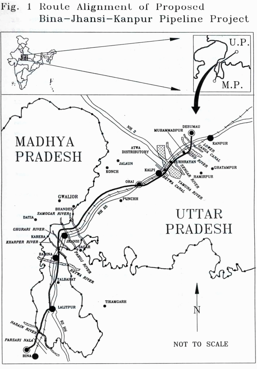
M/s Bharat Petroleum Corporation Ltd (BPCL) is setting up a 6 MMPTA (Million Metric Tonnes Per Annum) refinery at Bina in Madhya Pradesh as a joint venture with Oman Oil Company (OOC). Marketing and distribution of the refined product would be handled by BPCL for which it is setting up a Product Terminal next to the refinery. The refined products will be despatched by rail, road and through pipeline to high consumption areas in Uttar Pradesh and surrounding areas of neighbouring states. 2.1 PROJECT DETAILS A 361 km long pipeline is planned, starting from product terminal at Bina to Kanpur via Jhansi for transporting mainly Motor Spirit (MS), High Speed Diesel (HSD) and Superior Kerosene Oil (SKO). The proposed pipeline would take off from 0/00 km within the plant area (Latitude 24o16' and Longitude 78o11') at the marketing terminal point at Bina and would terminate at Desumau (Fig. 1), Kanpur (Latitude 26o26' and Longitude 80o07') with a Tap-off point at Jhansi (Latitude 25o32' and Longitude 78o30' ). The proposed pipeline would fall in the administrative jurisdiction of Sagar/ Tikamgarh District in Madhya Pradesh (M.P.) and Lalitpur, Jhansi, Jalaun and Kanpur districts in Uttar Pradesh (U.P). The proposed tap off point would fall between Datia-Jhansi rail section and Datia- Jhansi SH-37, and would be covering an approximate area of 51 acres. This area under Karari village of District Jhansi in the state of Uttar Pradesh is already under acquisition by BPCL and the boundary has been secured with wire fencing. 2.2 PIPELINE DESIGN AND CONSTRUCTION DETAILS 2.2.1 Design details The pipeline diameter (40.64 cm) has been calculated on the forecasted throughput of 2.835 MMTPA which will increase to 3.1 MMTPA. The pipeline grade and thickness will be selected after carrying out detailed engineering studies as per the design practices conforming to International Specification viz. ANSI B 31.4, Oil Industry Safety Directorate (OISD) standards etc. 2.2.2 Construction details The pipeline will be buried normally at a depth of 1m below ground level excepting in few critical areas like road, rail/river crossings where the depth of cover would be more depending on design considerations. 2.2.3 Protection system The cross country pipeline will be protected by both internal and external measures. Corrosion protection system Corrosion protection for the internal surfaces of the pipeline is provided by injection of a corrosion inhibitor at the originating station with specified dosages. The external corrosion protection normally is a combination of passive and active protection techniques including pipeline coating & wrapping and Cathodic Protection System. Cathodic protection The pipeline is planned to be protected cathodically by a permanent impressed current system. The cathodic protection system will be designed taking into consideration the soil resistivity along the pipeline route, stray current interferences due to overhead railway traction, transmission lines and adjoining steel structures etc. 2.2.4 Supervisory control system and patrolling The SCADA system is envisaged to provide real time status of pipeline operating parameters and Leak Detection System. The main functions of SCADA are; Pipeline Operation Monitoring, Remote Valve Operation, Leak Detection and Cathodic Protection Monitoring etc. This system is being considered because of its precision in sensing leakage, pressure built up in the pipeline and also for providing a signal to the valves for quick closing, thereby ensuring the control of the spill quantities to the bare minimum in the event of leakage of products from the pipeline. Regular patrolling of the pipeline will be carried out along the pipeline route. 2.3 PIPELINE ROUTE DESCRIPTION 2.3.1 Landuse and terrain The pipeline route is covered by a network of National Highways(NH), State Highways (SH), District and taluk level roads, rivers and nallahs. The intervening terrain en route the pipeline include flat terrain, knobs, Reserved Forest, wetlands and hills. The proposed route for cross country pipeline is planned to take off from the proposed Central India Refinery (CIR) marketing terminal at Bina in Sagar District of M.P. It traverses cross-country, crossing Parasari stream at km 10/00, Bangarh-Kanjiya metalled road at km 12/59, Khirla stream at km 13/36 and Narain river at km 23/17. The pipeline route passes through Dewal Reserved Forest before crossing Narain river and after crossing the Narain river, it passes through Amaukhera Reserved Forest, Dhojri Reserved Forest, Chandpur Reserved Forest and Sagoria Reserved Forest till about km 35/00. Narain river is the inter state boundary between U.P. and M.P. After km 35/00 the pipeline route runs almost West of Bina-Jhansi rail line upto km 55/00. At km 55/89 the pipeline crosses Bina-Jhansi rail line and traverses through cultivated lands and barren patches. The pipeline route passes through cultivated land, barren patches and small streams till it crosses, Lalitpur-Jhansi NH26 road at km 92/02. It passes through Ghisauli Reserved Forest, cultivated land and rocky knobs till it finally crosses Betwa river at km 106/96. The pipeline traverses through barren rocky land and Reserved Forest and runs about 3 km West of Babina cantonment till it crosses Babina-Jhansi road NH26, km 126/01. The pipeline crosses Ghurari river at km 126/92 which forms the inter state boundary between M.P. and U.P. state. The pipeline after Ghurari river crossing passes through cultivated land, BHEL railway siding at km 130/46 and again crosses the Central Railway siding at km 130/46 and again crosses the Central Railway line at km 132/99. The pipeline route runs about 6 km West of Jhansi township till it crosses NH25, Shivpuri-Jhansi road at km 145/66. It crosses Samogar river (km 149/33), and after criss-crossing cultivated land and barren patches it crosses Central Railway (C.R.), Datia-Jhansi rail section at km 155/00 and Datia-Jhansi SH-37 road at km 155/57. After crossing SH-37, the pipeline turns East and runs through cultivated land till it crosses Pahuj River at km 161/71. Minor streams, roads are crossed till the pipeline crosses Bhander branch (Betwa canal) canal at km 188/61. The terrain is moderately flat and cultivated. The pipeline again crosses Simiriya distributary at km 197/61 and Betwa canal at km 202/08. After crossing Betwa canal, the pipeline runs parallel and North of Central Railway, Jhansi-Kanpur broad gauge line. It crosses minor roads and runs close to a hill at km 215/00 till it crosses Punchh canal (km 224/7) and Hamirpur branch canal at km 229/63. The pipeline runs through fairly flat terrain crossing cart-tracks, roads and cultivated lands till it crosses Kunch-Ait broad gauge line, (km 244/39) and Akori distributary, (km 246/87). Due to the canal system the area is well irrigated. The pipeline again crosses Ait distributary at km 251/42. Dhagwan Kulan township is about 1 km West of this crossing. After crossing the Ait distributary, the pipeline crosses the C.R., Jhansi-Kanpur Broad Gauge line (km 252/60) and Ait-Orai, NH-25 road, (km 260/80). The pipeline crosses Orai-Muhammadabad SH-21, (km 269/56). Orai township is about 2 km North West of this crossing. The pipeline runs through fairly moderate terrain criss-crossing minor roads, streams and cultivated land. Ait distributary is crossed at km 284/27 and then again the pipeline runs parallel to the Jhansi-Kanpur broad gauge line from km 290/00. It crosses Kalpi distributary canal at km 295/00. The pipeline runs about 800 m East of the rail line crossing SH-2 at km 300/09. The pipeline runs through Kalpi Reserved Forest and Alampur Reserved Forest between km 301/50 to km 304/50 through broken ground/ravines till it crosses Yamuna River at km 307/00. The pipeline again passes through broken ground till km 310/00 and crosses the Sikandra, distributary at km 312/27. The terrain is flat and it crosses the SH-46 road at km 317/16. After crossing SH-46, the pipeline crosses minor roads, streams, cultivated lands till it crosses lower Ganga canal at km 338/86. The pipeline crosses Central Railway line at km 342/27 and from km 350/00 takes a course towards North crossing Ghatampur distributary at km 356/39 and Rind river at km 359/47. The stretch between km 310/00 to km 361/06 is well developed and under intense cultivation. The route description of the proposed pipeline highlights the following major crossings en route the proposed pipeline Railway lines - 8 National Highway - 5 State Highways - 7 Asphalted roads - 8 Major rivers - 2 Minor rivers - 9 Reserved Forests - 6 |
Last Updated: October 7, 2015


