
Methodology
|
The usefulness of EIA as a robust and reliable tool for promoting economic and industrial development on the environmentally sound footing has already been accepted the world over. Methodologies for EIA have been well established now (Wathern, 1988). These are however often required to be tailored to address the concerns of the specific projects. Primarily, EIA involves identification of physical, chemical, biological and ecological parameters and subsequent measurements for determining the baseline status of the project environment. The scope of work under the EIA study of the proposed pipeline is only limited to ecological assessment. Methodologies adopted for the ecological assessment required to be undertaken for this project are in accordance with standard methodologies that have been established for ecological assessment (Treweek, 1995) and those that have been further refined during the earlier assessment of ecological impacts of pipeline projects (WII, 1995b) in Indian scenario. The specific tasks that are required to be accomplished to address the overall objectives of the study are: 1) Familiarisation with the project profile, design and operational details. 2) Identification of primary categories of ecological areas/wildlife habitats. 3) Identification of critical environmental concerns. 4) Formulation of mitigatory strategies wherever required. The following approaches have been adopted for generating relevant information and the ecological data for impact assessment.
3.1 USE OF DOCUMENTED INFORMATION The project profile provided by the authorities of BPCL and the spatial representation of pipeline route on the 1:50,000 toposheets provided a fair understanding of the project location, profile, purpose and the ecology of the areas en route the pipeline. Extensive literature search provided the much needed insight into floral and faunal values of the area. Other secondary sources of information included scientific and technical reports, working plans of the State Forest Departments and census records. Discussions with the officials of the State Forest Departments, local NGOs, scientific and research personnel of academic institutions, naturalists and local people provided additional information on the regional ecology.
3.2 RECONNAISSANCE SURVEY Reconnaissance or rapid survey is an integral part of the EIA study. This kind of `one off' survey in the initial phase of the study conducted at a relatively superficial level are used to identify habitats or communities which merit more intensive surveys. The reconnaissance of the entire area between take off point at Bina and the terminal point at Desumau, near Kanpur was a primary step in the EIA of this project. For the purpose of reconnaissance, the entire length of the pipeline route was divided into eleven segments each comprising of 10 km length of pipeline route. Ecological assessment was confined within a 1 km wide pipeline corridor. Survey points were located to cover all representative habitat categories. The specific notes on each survey point were recorded in a specially designed data sheet (Appendix - I & II). Table 1 provided the results of reconnaissance for scoping. Table 1. References points surveyed along the proposed BJKP Pipeline route during the reconnaissance.
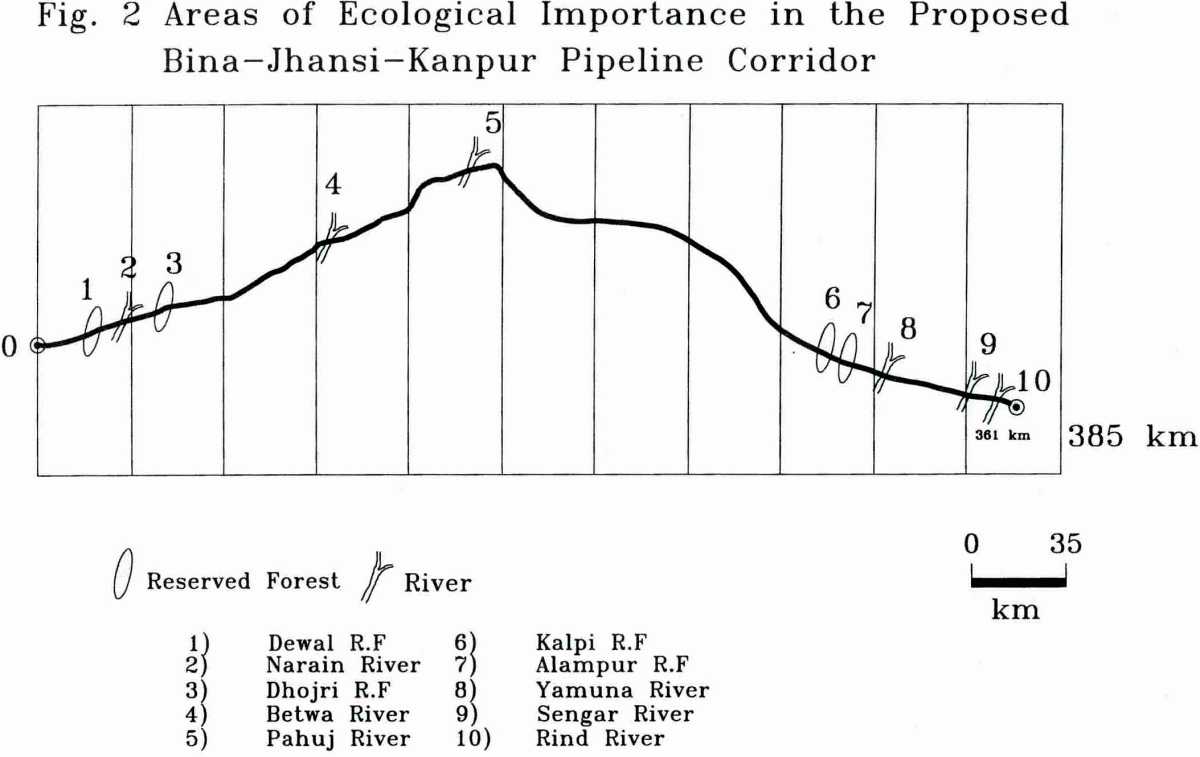
3.3 SCOPING Scoping refers to the final assessment of the actual limits of the study. An attempt is made to identify the attributes or components of the environment for which there is public or professional concern, or both, and to which the assessment should primarily be addressed. Each of the environmental attributes or components identified as a result of a scoping exercise is referred to as a `critical ecosystem component' or `areas of ecological significance' in this document. Fig. 2 indicates the ecosystems/habitats identified for detailed studies through the process of scoping.
Five areas of the forest namely the Reserved Forest of Dewal; Dhojri and Chandpur and Kalpi and Alampur of Sagar, Lalitpur and Orai Divisions en route the pipeline have been identified as terrestrial habitats that would be required to be intensively surveyed for the assessment of ecological impacts of the proposed pipeline. Table 2. Reserved Forest areas en route Bina-Jhansi-Kanpur pipeline project.
Six rivers (Table 3) viz. Narain, Betwa, Pahuj, Yamuna, Sengar and Rind en route the pipeline have also been identified as wetland habitats that are required to be intensively surveyed for the assessment of impacts of Bina-Jhansi-Kanpur pipeline project on the wetland values.
Table 3. Wetland habitats en route Bina-Jhansi-Kanpur pipeline project.
3.4 INTENSIVE STUDIES The areas of ecological importance identified through scoping were revisited for collecting detailed information on natural environment through predetermined ecological and biological parameters and indicators. Sample plots (10 m radius) were laid in each of the representative forest areas for generating information on vegetation structure and terrestrial ecology. General surveys were conducted for recording direct and indirect animal evidences, existing levels of biotic pressure and other important variables. Surveys were also conducted for evaluation of wetland status prior to an evaluation of the project related impacts. All the six river corridors were surveyed on foot both, upstream and downstream of the pipeline crossing. Information on river bank characteristics, aquatic flora and fauna (fishes, reptiles and aquatic mammals) and existing sources of biotic pressures were collected during the survey. Informal dialogue with local people and naturalists was also used to supplement information on wildlife values of all the areas identified for detailed ecological assessments (Plate 1).
|

Last Updated: October 7, 2015


