Impact Identification
|
Impact identification involves measurement of some select attributes or characteristics, for which we can actually collect data, perform analysis and estimate future conditions with and without the project. The preceding section is a compilation of baseline information on select parameters that determine the environmental setting of the VV pipeline project. This baseline information has been used here to determine environmental impacts of the proposed development. Project induced effects can act directly upon a resource or an environmental condition and can result in direct or primary impacts, or impacts can result from effects on other attributes which in turn affect the attributes being studied and can be considered as secondary impacts. An attempt has been made to identify the project related impacts on different components of the biological environment of the project area. The significance of such impacts have also been determined based on uniqueness and fragility of habitat types, status of animal/plant species likely to be impacted, as well as duration, reversibility and areal extent of the change associated with the project activity. 4.1 Impact on Reserved Forests
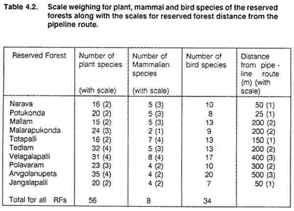
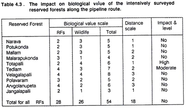
4.1.1 Anticipated Impact on Forests during construction 4.2 Impact on Wildlife A comparison of the scales of biological values and impact is shown in Table 4.2. The results show that Totapalli RF with high biological value (scale = 6) and lying close to the proposed pipeline route (scale = 1) will have an high impact. Similarly, Tedlam RF with high biological value (scale = 7) and by its distance from the pipeline route (scale = 2) will have moderate impact. However, Velagalapalli RF which has high biological value (scale = 8) would not be impacted due to its distant position from the pipeline route (scale = 3). Although Narava, Potukonda and Jungalapalli RFs lie close to the pipeline route (scale = 1), their biological values are not high (scale = 3-5) and as such an impact or loss of these values is not foreseen (Table 4.3).
From the above observations, it is evident that the proposed pipeline route have no impact on the Reserved Forests. Since, most of the RFs are on hills, these would remain unaffected by the proposed pipeline route has been aligned generally in valley plains or in some cases at the base of the hills.
|
Last Updated: October 7, 2015


