Profile of The Project and Details of the Mine Lease
|
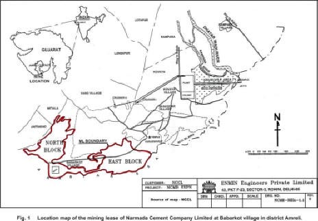
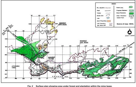
The 565.94 ha limestone mining lease of Narmada Cement Company Limited is located in Babarkot village of Jafarabad taluka in Amreli district of Gujarat (Fig. 1). The area was explored by M/s Chowgule and Co. (P) Ltd. during 1975-78 and the lease was executed by Government of Gujarat in the year 1979 for twenty years. The area forms part of the coastal tract along the Arabian sea and represents a gently undulating topography. The highest elevation in the mine area is 40 m Reduced Level (mRL) towards north-east. The general ground level ranges between 10 – 30 mRL. The entire lease area is divided into two blocks, namely North block and East block. Land use details of the area show that lease area comprises of 160.64 ha agricultural land and 405.30 ha of the government land. About 31.3% of the government land in the lease area comprises of forest land (177.25 ha). The total forest area (177.25 ha.) under the initial mining lease area in Babarkot village comprised of 80.93 ha. (in Survey No. 69/P) and 96.32 ha. (in Survey No. 366/P) in two separate blocks (Fig. 2).
The Babarkot Limestone Deposit area constitutes a part of the Coastal Saurashtra Peninsula in the State of Gujarat. In this area, the Arabian Sea Coast, which forms the southern limits of the leasehold, is in an east-west spread, while the Jafarabad creek defines the western limit. The deposit is characterized by immature badland topography of raised undulating terrain. The limestone bed is 10m to 30 m in thick, generally underlain by marl. A prominent geomorphic feature of the area is the steep sea-shore limestone cliffs along the shoreline of the Arabian Sea, rising at places to 10 – 20 m above MSL. The shoreline in the western part along the Jafarabad Creek is devoid of any cliffs and is characterized by tidal flats. Further west, Jafarabad Creek enters several kilometers into the land, in an area characterized by low lying wide tidal flats, extensively used for salt panning. The Babarkot lease area is characterized by extensive exposures of miliolitic limestone with maximum one km width from the sea shore. Miliolitic limestone is formed by the deposition of the calcic shell fragments of Miliola and related organisms, which is now exposed due to regression of the sea. The limestone bed is 10 m to 30m thick upto zero MSL, the deposit shows enrichment of calcium content at the upper layers. It is underlain by calcareous shale or marl. The deposit is generally bare and it is only at a few places, that is covered by a thin layer of overburden and soil, only 0.3 to 0.5 m of silt material. |
Last Updated: October 7, 2015


