|
Environmental Impact Assessment (EIA) involves identification, quantification, prediction and evaluation of the impacts of the various development activities on natural resources and the environment (IUCN, 1980).
Three criteria for identifying significant impacts on the environment were suggested in the World Conservation Strategy. The first is concerned with the length of the time and geographic area on which the effect will be felt. The second criteria is concerned with the urgency. How quickly a natural system might deteriorate and how much time is available for its enhancement, and finally the third criteria takes into account the degree of irreversible damage to communities of plants and animals, life-support systems and to soil and water.
2.1 MACRO LEVEL ASSESSMENT
Macro level assessment is conducted to collect the basic information about the project area prior to the reconnaissance. This is done with the help of relevant maps and literature collected from the project proponent and other sources. For the proposed project, relevant maps and toposheets of the area on a scale of 1:50,000 were provided by Oil India Ltd. and Engineers India Ltd. respectively. These maps and toposheets were referred extensively to determine the areas of interest en route the proposed pipeline. Other project documents and the feasibility reports of the project (prepared by EIL) were also referred for the details on alternative route selection, construction technology and all other actions involved in the project implementation.
Secondary information about the proposed project and its environment was collected from the technical personnel of Oil India Limited, Gauhati and biologists of Dept. of Zoology, Gauhati University. In addition to this, secondary published information from scientific documents was also perused.
2.2 RECONNAISSANCE OF THE PROJECT AREA
The reconnaissance of the Jorhat-Numaligarh Pipeline Project was undertaken during April 1995 to evaluate the ecological values of different wildlife habitats lying en route and to select the areas for intensive studies.
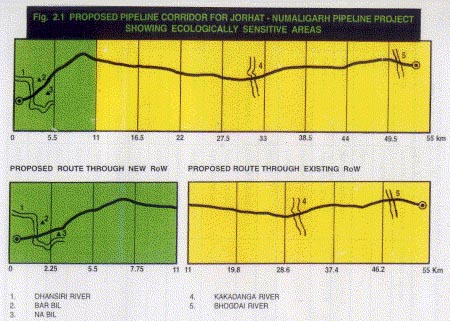
The first stretch of 42.5 km of proposed pipeline between Jorhat and Bholaguri, would be aligned within the existing RoW of Naharkotiya-Barauni crude oil pipeline. Whereas, for the remaining stretch of 12.5 km, between Bholaguri and Numaligarh Refinery a new RoW would have to be acquired. Since, the 42.5 km stretch of the proposed pipeline would be aligned within the existing RoW, no significant changes in wildlife habitat and their values are expected to result from this new section of pipeline. Nevertheless, observations were made on selected points on this stretch. For the remaining section of 12.5 km, new RoW would be acquired. Greater emphasis has been given on the evaluation of wildlife values within the new route corridor.
A total of 17 reference points were surveyed (Table 2.1), of which nine were within the existing RoW and the remaining eight were in the new route. At each reference point, notes on location, landuse category/legal status and status of wildlife values were recorded. Based on this information, ecologically sensitive areas were selected within the proposed pipeline corridor for intensive studies (Fig. 2.1).

|
S. No.
|
Location
|
Landuse/Legal status
|
Wildlife values
|
|
1
|
Jorhat
|
Pumping station
|
-
|
|
2
|
-do-
|
River
|
-
|
|
3
|
Bhatemara
|
Human habitation
|
-
|
|
4
|
Charingiagaon
|
Agricultural land
|
-
|
|
5
|
Ahomgaon
|
Human habitation/ agricultural land
|
-
|
|
6
|
Hahpani
|
River
|
+
|
|
7
|
Barua Bamangaon
|
Human habitation
|
-
|
|
8
|
Bar
|
Human habitation/ agricultural land
|
-
|
|
9
|
Habigaon
|
Human habitation/ agricultural land
|
-
|
|
10
|
Badulipur
|
Agricultural land
|
-
|
|
11
|
Bholaguri
|
Human habitation
|
-
|
|
12
|
Kumtai
|
Tea garden
|
-
|
|
13
|
Nagaon
|
Agricultural land
|
-
|
|
14
|
Singhala
|
Beel
|
+
|
|
15
|
Singhala
|
Beel
|
+
|
|
16
|
Barguriagaon
|
River
|
+
|
| 17 |
Numaligarh |
Refinery site |
- |
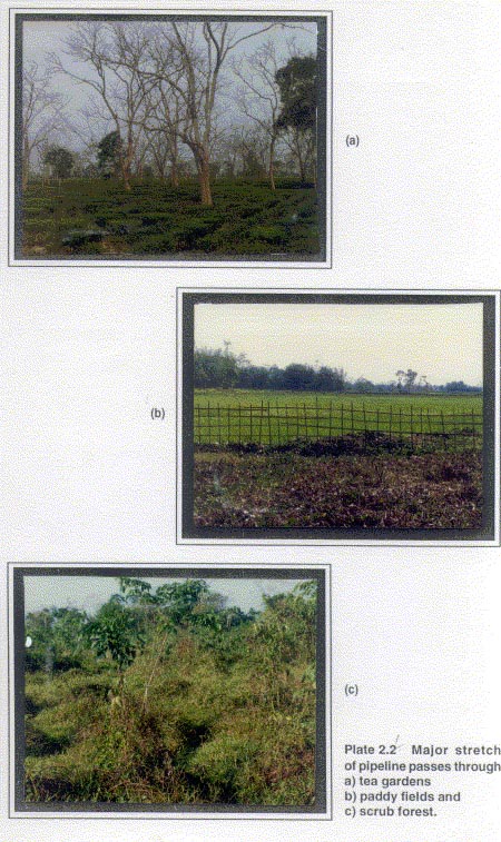
It is evident from the proposed pipeline route alignment that the pipeline would largely traverse through privately owned tea gardens, paddy fields, wetlands and a small patch of scrub forest (Plate 2.1). Since, the evaluation of project impacts on the tea gardens and paddy fields were not included within the scope of this study, and the scrub forest patch through which the pipeline would traverse is too small to support any wildlife species of conservation significance, emphasis has been laid on the identification of impacts of project on wetlands. For the purpose of this study, wetlands will include river corridors and village ponds that are also known as `beels' locally.
2.3 INTENSIVE STUDIES
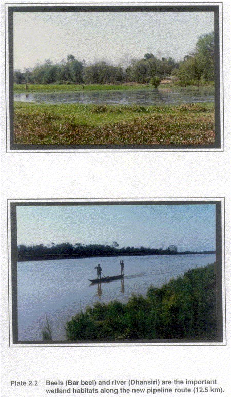
Based on the observations of the macro level assessment and reconnaissance, four wetland areas have been identified for intensive studies (Table 2.2), Two river corridors, viz: Dhansiri and Kakadanga river and two beels (Plate 2.2).
Table 2.2 Areas identified for intensive studies
|
Sites of ecological importance
|
Location
|
Species present
|
Conservation value
|
|
Kakadanga river
|
Hahpani
|
Fishes, turtle and birds
|
Low
|
|
Bar beel
|
Singhala
|
Fishes, turtle, and birds
|
Moderate
|
|
Na beel
|
Singhala
|
Fishes, turtle, and birds
|
Moderate
|
|
Dhansiri river
|
Barguriagaon
|
Fishes, turtles, birds, dolphins and otters
|
High
|


Out of these, three areas, viz: Dhansiri river, Bar beel and Na beel are located within the stretch of proposed pipeline route that would require new RoW. Kakadanga river which is one of the sites identified for detailed study is located in the stretch of proposed pipeline aligned with the existing RoW of Naharkotiya-Barauni crude oil pipeline. For the collection of data on different biological parameters of these areas, site specific methods were adopted.
2.3.1 Wetlands
Wetlands are lands, having the water table at, near or above the land surface, or which remains saturated for a long enough period to promote the aquatic processes as indicated by hydric soils, hydrophytic vegetation and various kinds of biological activities, which are adapted to the wet environment (Tarnocai, 1979).
As mentioned earlier two kind of wetlands viz: river corridors and beels are located en route the proposed pipeline.
2.3.1.1 River Corridor
A river corridor includes stretch of river, its banks and the adjacent land (about 50m wide). Parameters such as physical features of the river, bank zone habitat, adjacent landuse, aquatic fauna and the existing level of biological disturbances were considered for collection of baseline information of these river corridors. In the present study the following two river corridors were surveyed:
Dhansiri River
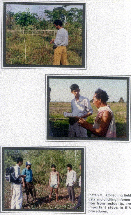
The proposed pipeline route would cross Dhansiri river near Barguriagaon village. The width of the river bed at the proposed crossing point for pipeline is approximately 30m. The water level varies in different seasons. This river corridor was surveyed on foot for a distance of approximately one km in both upstream and downstream directions to collect information on parameters specified above. Data on aquatic faunal diversity was collected by direct observation of the fish catches. Interview with local people supplemented the secondary information (Plate 2.3). Information on birds and other animals was collected by seeking the help of local people in identifying their pictorial representations.
Kakadanga River
The proposed pipeline route would traverse through Kakadanga river corridor near Hahpani village. The width of this river at the proposed crossing point for pipeline is approximately 20m. It is also a perennial river, with fluctuating water levels. This river corridor was also surveyed upstream and downstream for a distance of approximately one km to collect information about the river features, existing status of wildlife species and existing level of biotic disturbances. Local villagers and fishermen were also interviewed to collect the information about the presence of any other wildlife species of conservation significance.
2.3.1.2 Beels
Beels are the village ponds. They are derelict and semi-derelict wetlands constituting parts of floodplains of Brahmaputra and form vitally important fishery resources of Assam. Beels are of two types. Lake-like beels are wide, shallow, with an irregular shoreline and are connected to rivers through channels. Ox-bow beels, are mostly parts of abandoned river courses and are relatively long, narrow and have a curved or serpentine shape. The formation of many large beels has favoured extensive development of marginal and submerged vegetation, dominated by macrophytes. These beels constitute over 80% of Assam's lentic waters. Some are state-owned (Departments of Flood Control, Irrigation, Agriculture and Fisheries) and others are privately owned. The beels are mainly exploited for their fishery resources (WWF-INDIA, 1993).
Two beels viz: Bar beel and Na beel, located en route the proposed pipeline belongs to the category of ox-bow beels. These beels were studied intensively to find out their present ecological status and to evaluate their floral and faunal values. Information on the avifaunal, reptilian and fish species was collected by both, direct observations and indirect evidences and also through the secondary sources.
|


