|
Vegetation mapping is an important prerequisite to an ecologist, botanist, forester or a planner and its utility is manifold viz. (i) Vegetation maps presents an inventory of existing plant communities, their location, extent and geomorphological distribution in the landscape at the time of mapping, (ii) Vegetation maps are scientific tools for analyzing the environment and the relationship between vegetation and the site in which it occurs, (iii) Vegetation maps are valuable standards of reference for observing and measuring changes in vegetation, their direction and speed i.e. rate of change, (iv) Vegetation map can serve as a scientific basis for planning future landuse (Kochar, 1988).
4.1 Objectives
To prepare baseline data on vegetation with respect to its type and density in the PPAs using remote sensing technique and geographic information system.
4.2 Vegetation
Forest types of India have been classified into 16 groups by Champion and Seth (1968). This classification is based on various climatic climaxes depending on sites and soils of medium depth and fertility and also takes into account the edaphic climaxes. The PPAs fall in Deccan biogeographical zone and have been classified as Deccan peninsula (6A) biogeographic zone (Rodgers and Panwar, 1986). Champion and Seth (l.c.) classified these forests as tropical dry deciduous forest and subgrouped them as southern tropical dry deciduous forests. It is formed by a mixture of trees practically all of which are deciduous during the dry season, usually for several months, though some for a short period only (Champion & Seth, l.c.) in the PPA altitude varies from about 200m to 440m. If compared with wet tropical forest the number of species is less, however, climaxes due to edaphic and biotic factor can be observed. The PPA have Teak as the most prominent tree species and forest is classified as dry teak bearing forest. Most of the species in such forest are prolific coppicer. Canopy is close i.e. density is more than 60%. Trees are sufficiently large and well grown. Due to edaphic factors and moisture content in the valleys or on hill tops the species composition changes. One can observe the difference vary conspicuously while moving away from the valleys. Most of the forest in the PPAs is dry deciduous except in most valleys where some evergreen to ‘semi evergreen’ shrubs or small trees occur. The PPAs have mixed dry deciduous forest with teak usually forming the major proportion of the vegetation (Puri, 1960 a,b).
A detailed study on the flora of the PPAs has been done by the WII (Anonymous 1994). Among the dominant trees forming the top canopy are Tectona gfandis (Teak), Terminalia tomentosa, Maduhca indica, Anogeissus latifolia, Mitragyna parvifolia, Boswellia serrata, Hardwickia binata. On the hilltops with bouldery soil are Acacia catechu, Lagerstroemia parviflora and Holarrhena pubescens, Dendrocalamus strictus (Bamboo) is found in the valleys along with other trees. Ocimum species and Cassia tora occur gregariously in the forest blanks.
Good (1974) categorized vegetation on India into 5 Floristic regions out of the 37 floristic regions of the world. These are 3 – Sino-Japanese, 4 – West and central Asiatic, 9 – African-Indian desert, 17 – Indian region and lastly 18 – Continental South east-asiatic. The proposed PPAs fall under Indian region which has its own unique indigenous flora.
A very remarkable species with disjunct distribution is Hardwickia binata which is found in the east west oriented hills of Satmala, Satpura, Vindhyan, Mahadeo or in the north-east / south-west oriented hills of the eastern ghats in Andhra Pradesh and Tamilnadu and Karnataka (parts). It occurs on a variety of geological formations (gneissic complex, sandstone, quartz, (Deccan trap) and soils (Skeletal, gravely to deep black clayey).
Mehar-Homji (1977) has worked out the percentage of various floristic elements in the dry deciduous forest. In the teak forest, Indian elements are more than 50%, Indo-Malayan elements are about 24%, Tropical Asia-Australian elements about 5%, Tropical Africa-Asian elements about 3.7% and also shares small percentage with other regions. Interestingly the are is very rich and supports its own unique flora.
The probable trends of progression of these dry deciduous Teak forest is than decrease in overall average rainfall results in (a) disappearance of teak (b) followed by that of Terminalia tomentosa and Anogeissus latifolia (Mehar-Homji, l.c.)
4.2.1 Forest types in the area
Following are the forest types occurring in the PPAs (after Champion and Seth l.c.)
(i) Riparian Forest (4E/RS1)
The vegetation along the course of rivers, rivulets, streams and in the sandy-rocky riverbeds is quite characteristic. Streams have good soil whereas rivulets have stony boulders or only exposed eroded rocks. Trees are taller and are either evergreen or semi-evergreen. Frequent trees are Terminalia arjuna, Eugemia app., Ficus spp. Along with Bamboo (Plate 7).

(ii) Very dry Teak Forest (5A/C1a)
The very dry teak forest of very poor quality can be found on the fringes of Nimanpur R.F. The ground is stony or with small pebbles. Height of the Teak tree is short and truncated, Density is around 0.2. Soils are very shallow. The characteristic species are mainly Tenctona grandis (occur in pure forms) and Boswellia serrata. Aegle marmelos is also found scattered on stony and bouldery soils. Ground flora is quite poor. Terrain is plain to gently undulating. Transitional type showing mixture of Aeogeissus latifolia and teak on exposed sandstone with basalt boulders (Plate 2) also occur.
(iii) Southern dry mixed deciduous forest (5A/C3)
In these forests a mixture of different species occur. These are usually found in the valley slopes or on gently undulating plains. Prominent species occurring in mixture are Terminalia tomentosa, Hardwickia binata, Boswellia serrata, Acacia catechu, Lagerstroemia parviflora, Aegle marmelos (Plate 4).

(iv) Dry Teak Forest (5A/C1b)
Almost pure teak is found on 'murram' and black cotton soils overlaying trap, Dry teak forest occur through out the area. Teak forms the major portion of the forest on shallow porous or stiff clayey soils. Teak grows in almost pure forms and also mixed. Teak pole quality is better in the moist plain areas. Besides, Tectona grandis other species are Aegle marmelos, Boswellia serrata, Hardwickia binata, Ougenia oojeinensis, Terminalia tomentosa. Holarrhena pubescens, Nyctanthes arbor-tristis etc. are most common second storey plant species (Plate 2).
(v) Boswellia Forest (5/E2)
Boswellia forest is an edaphic climax. These can be seen in large areas in Nimanpur R.F. on low undulating hills on Vindhyans and Punasa RF. Opplateaux in the Satpuras on hill spurs where soi1 is generally poor and shallow, pebbly or bouldery. Boswellia. occurs in pure formations and in consociation of other trees like Acacia catechu, Diospyros melanoxylon, Lannea corromendelica etc. A good quality natural pole crop of Boswellia occurs on flat plateau. Lagerstroemia parviflora forms the second storey and occurs scattered. Trees in general are 12-15 m tall and top canopy is uniform.
(vi) Hardwickia Forest (5/E4)
Hardwickia forests occur as edaphic climax in the area. These forests occur in shallow, hard, gravely soils over the traps. These forests normally occur in very gently undulating valley plains in Nimanpur and Punasa RF. and on slightly more undulating hills in Main Vindhyan and Chandgarh RF. Trees are very tall with good pole crop. These occur in small pure patches to mixed with Tectona grandis, Lannea corromendelica, Lagerstroemia parviflora and Boswellia serrata (Plate 3 and 4).
(vii) Dry Bamboo Brakes (5/E9)
Bamboo brakes are again a type of forest governed largely by edaphic factors and occur in small patches. In PPAs it may occur in shallow riverbeds along with other species, here it is codominant whereas in more drier areas it dominates. Dendroca/amus strictus is the only bamboo species and its associates may be Tectona grandis, Boswellia serrata etc. Bamboo brakes are scattered in PPAs (Plate 8).
(viii) Deciduous Scrub (5/DS1)
Dry deciduous scrub types of forests are the formations due to degradation in site quality. The soil is thin and sandy. Granite stones and pebbles along with rocky exposures are abundant. Such formations occur on exposed flat hill tops which are gently undulating. Nimanpur RF towards Narmadia river largely has this type of formations. Main species are Holarrhena pubescens, scattered and stunted teak along with Ocimum americana.
(ix) Dry Savannah Forest (5/DS2)
"There are no true savanna types of vegetation in India" (Puri et al.1989). The grasslands with scattered trees of Acacia catechu, Lagerstroemia parviflora, Boswellia serrata etc. occur on the hill tops. Grasses viz. Themeda quadrivalvis, Aristida spp, Heteropogon contortus etc. are dense and up to 1 m tall. The surface is extremely stony and with rock crop out. Trees are scattered. Chandgarh RF. and Main Vindhyan RF. have such grassland areas (Plate 6).
4.3 METHODOLOGY
4.3.1 Satellite Data Used
False Colour Composites (FCC) of SPOT-2 imagery with following details have been used.
Satellite : SPOT-1
Sensor : HRV-2 MLA
FCC Bands :1,2,3 (8GR)
Projection : Polyconic
Data type : Geocoded
Scale : 1:50,000
Table 4 shows the details of the data products used:
Table 4 Details of satellite (SPOT) data used
| Path/row |
Map 10 |
Date |
Sun Elevation (degrees) |
Azimuth (degrees) |
| GRS<D208-305/40 |
558/3 |
'07.11.1988 |
48.81 |
158.30 |
| GRS 0208-305/40 |
558/7 |
07.11.1988 |
48.90 |
158.64 |
| GRS 0208-305/40 |
558/7 |
28.1.1.1988 |
43.54 |
158.60 |
| GRS 0209-305/40 |
558/11 |
28,11.1988 |
43.62 |
158.90 |
| GRS 0209-305/40 |
558/12 |
28.11.1988 |
43.80 |
158.83 |
4.3.1.1 Characteristics of SPOT Satellite
It is a French satellite launched by the European Space Agency. Following are the, salient
features of the platform and the sensors.
| Nature |
: |
SunSyncl:1ronous |
| Altitude (km) |
: |
832 |
| Orbital period (minutes) |
: |
101 |
| Inclination (degrees) |
: |
98.7 |
| Temporal resolution (day) |
: |
26 |
| Equatorial crossing (AM.) |
: |
10.30 |
| Sensor |
: |
HRV (push-broom) |
| Spectral Resolution |
: |
0.50 - 0.59 mm |
| (XS mode) |
: |
0.61 - 0.68 mm |
| |
: |
0.79 - 0.89 mm |
4.3.2 Survey of India Toposheets
The Survey of India toposheets numbered 55 B/c, 55 B/4 ,55 B/6, 55 B/7, 55 B/8.55 B/11, 55 8/12 (1 :50,000 scale) have been used.
4.3.3 Ancillary Data
Forests on 1 :50,000 scale and Compartment Maps of East Nimar and Dewas Forest Divisions have been used.
4.3.4 Visual Interpretation
4.3.4.1 Base map preparation and delineation of boundary
Base map preparation involved tracing of permanent features like river, perennial rivulets, roads metalled as well as cart track, habitations etc. using S.O.I. toposheets. Base map was prepared using S.O.I. toposheets on 1:50,000 scale using sheet no. 55 B/3, 4, 6, 7, 8, 10, 11, 12. A framework of outer boundary of PPA existed with WII. However, the finalization of outer boundary was done in consultation with FONS. Nimanpur R.F. in between Ratanpur and Pathar village was added after assessing the quality of the vegetation of that area. This is a large forest area with little biotic interference and hence warrants inclusion. The outer boundary was taken from Forest Compartment maps of Dewas and E. Nimar Forest Division. Some Compartment Maps were also used for delineation of boundaries between proposed Narmada National Park, and Omkareshwar and Surmanya Sanctuaries.
4.3.5 Mapping
A reconnaissance survey was conducted jointly by the teams of WII and IIRS during September, 1993. This formed the part of preliminary reconnaissance survey and its main objective was to have an idea about the vegetation, vegetation types which give the characteristic tone on satellite data. This visit involved transecting the different forest areas like Punasa Reserved Forest, Punasa Protected Forest, Chandgarh Reserved Forest, Chandgarh Protected Forest and Main Vindhyan Reserved Forest. Reconnaissance survey resulted in the generation of interpretation key.
Mapping of the various features on land surface using satellite hard copy data involves a set of activities. Present study involves the mapping of vegetation/Forest types using SPOT-MLA False Colour Composite which has very good ground/spatial resolution. Following were activities followed during the present study.
4.3.5.1 Ground Work
After acquiring preliminary knowledge about the vegetation types and physiography of the project area detailed ground work was taken up. A detailed ground truth was done in October, 1993. In this process different tonal variations, forest types/other features, on the images were marked and to correlate these with the ground features, sites were located using S.O.I. toposheets and information was gathered. This resulted in the preparation of interpretation key and determination of different categories of vegetation or the classification scheme.
4.3.5.2 Image Interpretation
The entire PPAs are covered by four geocoded SPOT images on 1:50,000 scale. The data is of November 7 and 28, therefore, most of the vegetation is with foliage. Area on the images falling inside the PPAs were interpreted using standard interpretation technique. The important image characteristics, viz., tone, texture, location, physiography etc. were used to discriminate, the different features of the classification scheme. Texture variations on the image were used to determine canopy closure (density).
4.3.5.3 Classification Scheme .
Champion & Seth (I.e.) described the forest types of this area based on the climate and edaphic climaxes.
Group 5. Tropical Dry Deciduous Forests
Subgroup 5A. Southern Tropical Dry Deciduous Forests
Subdivisions C1. Dry Teak bearing Forest
Subdivisions C1a. Very Dry Teak Forest
Subdivisions C1b. Dry Teak Forest
Degradational types
5/DS1 - Dry Deciduous Scrubs
5/DS2 - Dry Savannah Forest
Edaphic Climaxes
5/E2 - Boswellia Forest
5/E4 - Dry Hardwickia Forest
5/E9 - Dry Bamboo brakes
The vegetation of the PPA varies locally depending upon the terrain, site condition, moisture content and other edaphic and biotic factors. Thirteen categories of vegetation were identified based on the tonal, textural, locational characteristics on satellite data. Of these, Teak Forest, Hardwickia Forest, grasslands and riparian forest are found in pure forms while others form various associations depending upon the dominance and frequency of different species. The categories identified on satellite data are as below and Table 5 gives the details of interpretation.
| (1) Teak |
(2) Hardwickia |
| (3) Teak – Hardwickia |
(4) Teak-Boswellia |
| (5) Boswellia-Hardwickia |
(6) Boswellia-Acacia |
| (7) Acacia-Lagerstroemia |
(8) Boswellia-Hardwickia-Acacia |
| (9) Teak Mixed |
(10) Hardwickia mixed |
| (11) Scrub/Shrub |
(12) Grassland |
| (13) Riparian |
(14) Barren/Rock/Blanks |
| (15) Agriculture |
|
| (16) Water body |
(17) Sand |
4.3.5.4 Ground Check
Ground check was carried during the second week of January, 1994. During the process doubtful areas and the interpretation accuracy was checked, specially for the density categorization. Ground check was also undertaken to visit the areas not seen in the earlier field visits.

4.3.5.5 Finalization of mapping
After the ground checks all doubtful areas observed on the imagery were resolved, Interpretation key was finalized. And lastly the interpreted details were transferred on to the base map. Labels were written to depict the forest type as numerator and density class as denominator.
4.3.5.6 Creation of Database
Final map was digitized in the GIS domain using GRASS (Geographic Rural Analysis Support System). Attributes (feature types) were created for forest cover and density of the forest cover.
4.4 RESULTS AND DISCUSSION
Management of natural resources on a sustainable basis is increasingly becoming a necessity for the resource managers. Conservation of biodiversity is seen as the most immediate action for longer harvest of benefits by the society. Launch of Landsat-1 MSS satellite in 1972 by NASA of USA brought entirely a new era in space remote sensing techniques. Now the data is available for interpretation/mapping at less cost, least time and on repetitive basis. Subsequently, more satellites with better ground, spectral, radiometric and temporal resolution were launched. SPOT satellite, whose data is being used in this project, was launched from France. India launched its first Earth observation satellite IRS-1A in March, 1988 and IRS-1B in August 1991. It provides data with better spectral resolution which is helpful in better discrimination of the ground features, specially vegetation. Its utility has been tested for various kinds of resource mapping. IRS data is now going to be used world wide. The satellite imagery that are now available have really revolutionised the data collection system and are having an enormous impact on map content, design and application.
Vegetation mapping started in India in the mid 80s and grew from there to macro and micro levels. In this direction first nation-wide forest cover mapping was done in 1983 by National Remote Sensing Agency using 1972-75 and 1980-82 data. Thereafter, a large number of studies have been done by different centres of Department of Space and State Remote Sensing Centres and a few State Forest departments. Roy (1993) and Roy et al. (1993) have summarised the different studies carried on forest cover mapping, wildlife habitat evaluation, forest landuse mapping, grassland mapping, stock mapping, growing stock estimation, afforestation and social forestry, wasteland mapping and other utilities of remotely sensed data (Roy et al. 1985; Roy et al. 1986; Roy et al.1993b; Unni, 1983; Unni et al. 1986; Dutta et al. 1986).
In the PPAs the vegetation mapping has been attempted with two aspects in mind- firstly the mapping of forest types or association types and secondly the density of the canopy i.e. canopy closure using SPOT MLA FCC. The data at hand was very good for visual interpretation and was 100 % cloud free (November 7th and 28th, 1988). During this season almost all the plants bear leaves and only grasses start drying up.. "Even though the SPOT MLA has only three spectral bands but its ground resolution of 20 x 20 m helps to catch very fine details of land surface. Thus it was possible to visually discriminate 17 mappable vegetation types based on tone/colour, texture, location, shape etc. coupled with ground truth. Attempts to measure canopy closure have been made for forest type association (Maps 4, 5, 6 and 7).

Following is the brief description about the mapped units, floristics and location and how these appear on the satellite data. Three density classes: >60%, 60-40% and 40-10% canopy closure, have been attempted based on their textural variations.
(1) Teak Forest:
Teak occurs as the most frequent, abundant and dominant tree species throughout the PPAs. It occurs in pure patches in Main Vindhyan and Chandgarh Reserve Forests. Pure patches can be seen in undulating plains, top of the hills where soil depth is less. Soil is sandy (murrum). This category has more than 70% Teak trees and Aegle marmelos, Ougeinia oojenensis, Bombax ceiba etc. are intermixed. In second story Holarrhena pubescens is most frequent (Plate 2).
On satellite data the teak forest appeared in tones of bright red. Depending upon the canopy gaps the texture varied from very smooth (high canopy closure) to medium texture (relatively, more canopy gaps). At some places even though the tree canopy was open these forests appeared contiguous in red tones (pseudo-density) mainly due to the presence of thick large foliage of ground flora viz. Holarrhena pubescens, Nyctanthes arbor-tristis etc..
(2) Hardwickia Forest:
Predominance of Hardwickia binata is the characteristic feature of the type. These are found scattered in blocks and patches. Leaves are small, dark green and plants are nearly evergreen. These are mostly associated with valley slopes and plains. These occur mainly on shallow hard gravelly soils overtops (Plate 3).
On satellite image such forests appear blackish brown. Texture varies from smooth to medium depending upon the canopy closure and abundance of the mixed species like Lannea corromandelica, Lagerstroemia parviflora, Acacia catechu etc.
(3) Teak-Hardwickia Forest:
Valley plains with gentle undulations have Teak and-.Hardwickia occurring as mixed forest. The areas may be small patches to large and contiguous blocks. This association has these two dominant species. In smaller percentage other species like Anogeissus latifolia, Mitragyna parvifolia, Adina cordifolia etc. are associated.
These areas' on satellite data appear in brownish red tone. Due to the mixture of these two species texture is coarse. Such areas are in small to medium size patches.
(4) Teak-Boswellia Forest:
Tectona grandis is the most widely and predominantly distributed species in the area. On the hill top and plateaux it occurs in association with Boswellia serrata, In Punasa RF. where the drainage density is higher the plateaux are with such association.
On satellite image these areas appear reddish cyan. Such areas are scattered, Texture is medium.
(5) Boswellia-Hardwickia Forest:
Boswellia serrata normally occurs on the flat hill tops and grows in association with Hardwickia binata where the soils are sandy and pebble stones are scattered. Main crop is of Boswellia serrata, and in between intermixed grows the Hardwickia binata.
On satellite image this association appears dull brown with cyan tinge. Texture is coarse, because of the much dissected hill top. Contiguous patches forming a small unique association occurs in the Punasa RF. towards Tikari ghat and its surroundings.
(6) Boswellia-Acacia Forest:
Association of Boswellia serrata and Acacia catechu occurs on the steeper slopes along the Narmada river and Punasa RF. Boswellia dominates the canopy and Acacia occurs plentifully in second storey.
On satellite image this association appears in reddish cyan tone. Being intersected by the drainage, the texture is coarse.
(7) Acacia-Lagerstroemia Forest:
Associations of Acacia catechu and Lagerstroemia parviflora occur on hill tops where ground has medium sized stones. Tree density is poor. Ground is covered with tall grasses.
On satellite data this association appears in whitish yellow to pinkish cyan tones. Texture is coarse, the trees are interspersed in different numbers.
(8) Boswellia-Hardwickia-Acacia Forest:
This mixed association of three predominant species occurs in patches in Punasa R.F. Association is found on the very gentle, undulating hillock tops where soil is thin and rocks are exposed. Boswellia serrata occurs in. association with Hardwickia binata and Scacia catechu in large patches where there is grazing pressure.
On satellite data this association appears in blackish brown with red tinge. Texture is medium to coarse.
(9) Teak mixed:
Although Tectona grandis is the main dominating species of the area, it also occurs mixed with other species. Such forests occur on the hill slopes and in the valleys forming contiguous to large scattered patches. Other species occurring together are Dalbergia latifolia, Dendrocalamus strictus, Acacia catechu, Terminalia tomentosa, scattered Hardwickia binata etc. (Plate 4)
On satellite image these areas appear brown with blackish brown patches. Texture is medium to coarse. There is hardly any blank space in such areas. This is quite characteristic tone in satellite data.
(10) Hardwickia mixed Forest:
Evergreen Hardwickia binata occurs in the shallow valley plains, where undulation are less, soils are shallow, hard gravelly over the tops. Other species occurring in association are Boswellia serrata, Lagerstroemia parviflora, Diospyros melanoxylon, Acacia catechu and scattered trees of Tectona grandis (Plate 5).
On satellite data these patches occur in light blackish brown tone. Texture is coarse. Occurrence may be contiguous to scattered in patches.
(11) Scrub/Shrub:
Due to biotic pressure and also due to edaphic factors some sites have been degraded. Those on the hill tops with plenty of stones and rock outcrop are with Holarrhena pubescence, Ziziphus spp, stunted growth of grass tufts, stunted Tectona grandis, Anogeissus spp. etc. The cleared forest, where regeneration has not been possible due to grazing pressure, have Ocimum americana, Cassia tora etc.
On satellite data these areas appear blackish cyan to light cyan in tone. Texture is smooth to medium in some areas. In the Nimanpur R.F. most of the hill tops along Narmada river have such types of areas.
(12) Grasslands:
Grasses grow on the sites where the site has been subjected to some biotic pressure. Soil surface has medium size stones. Grasses grow up to 1 m tall. Grasses are also found as ground flora in less dense forest. Dominant grasses are Apluda spp, Themeda quadrivalvis, Aristida spp., Heteropogon contortus etc. and occur on hill tops (Plate 6).
On satellite image these areas appear as whitish yellow tone. Texture is smooth. Such areas are very few.
(13 Riparian Forest:
Riparian forests occur along the deep and moderately deep streams and rivulets. Therefore, such areas are narrow and linear. Soils are deep where the eroded clay and loam from upper reaches are deposited whereas on steep slopes stream beds are rocky. Terminalia arjuna, Eugenia, Ficus species etc. are the common characteristic species. Bamboo grows in association with trees (Plate 7).


On satellite data these areas appear black brown and texture is smooth. Narrow bands of such forests can be traced along the streams.
(14) Blank/Barren/Rock:
Rocks are exposed in. the Narmada river beds. In PPAs there are small numerous scattered blank patches in the forested areas.
Such areas appear light to dark cyan on satellite image. Texture is medium. High dip slopes are without good tree growth.
(15) Agriculture areas:
While proposing the PPA care has been taken to keep much of the agriculture areas outside. Still there are a few habitations in the forest. Soil in these areas is mainly black cotton soil. Some areas are single cropped and some double cropped. We have used one time data hence the delineation of single or double cropped areas has not been attempted.
On satellite image the agriculture fields can be identified very easily. Areas with crop appear light to bright pink, whereas current fallow land appear light to dark black. SPOT MLA data with a spatial, resolution of 20 x 20m is helpful in delineating such areas very clearly.
(16) Waterbody:
In the PPAs there are natural as well as man made waterbodies. The Narmada, river and its perennial tributaries are natural waterbodies. On the northern bank is Khadi Nadi and on southern bank is Chhota Tawa river.
Areas with water appear light to dark blue to blackish blue on satellite data. Texture is smooth.
(17) Sand:
Sand occurs on the banks of the river and rivulets. In the forested areas though the soil is sandy, sand does not form any marked feature.
Depending upon the moisture content in the sand, it appears white (dry sand) to light cyan to cyan (with water content). Texture is smooth. Such areas associated with islands in river beds or, banks.
4.4.1 Area Calculation
Table 6 gives the area details of these units.
Table 6. Area of forest types in PPAs
| S.N. |
Forest cover types/ association |
Area |
| Km2 |
% |
| 1 |
Teak |
222.48 |
29.39 |
| 2 |
Hardwickia |
22.64 |
2.98 |
| 3 |
Teak-Hardwickia |
105.02 |
13.83 |
| 4 |
Teak-Boswellia |
42.31 |
5.58 |
| 5 |
Teak-mixed |
148.28 |
19.59 |
| 6 |
Hardwickia-Mixed |
92.58 |
12.20 |
| 7 |
Boswellia-Hardwickia-Acacia |
10.44 |
1.37 |
| 8 |
Boswellia-Hardwickia |
25.70 |
3.38 |
| 9 |
Acacia-Lagerstroemia |
4.82 |
0.63: |
| 10 |
Boswellia-Acacia |
6.36 |
0.83 |
| 11 |
Scrub/Shrub |
41.19 |
5.43 |
| 12 |
Grassland |
0.24 |
0.03 |
| 13 |
Riparian |
2.52 |
0.33 |
| 14 |
Agriculture |
23.64 |
3.14 |
| 15 |
Sand |
2.20 |
0.29 |
| 16 |
Barren |
8.43 |
1.11 |
| 17 |
River Narmada |
25.51 |
17.86 |
As would have been expected the largest area has Teak forest (222.48 km2, i.e. 29.31%). Teak mixed occurs in 148.28 km2 (19.53%) and is the second highest. Hardwickia mixed has about 92.58 km2 i.e. 12.2%. Pure patches (i.e. more than 70% Hardwickia tree) of Hardwickia occurs in 22.64 km2 (2.98%). Teak-Hardwickia mixed forest area is about 105.02 km2 (13.83%). Boswellia occurs mixed with, Teak, Hardwickia and Acacia. Area of Teak-Boswellia is about 42.31 km2 (5.58%), Boswellia-Hardwickia has an area of about 25.70 km2 (3.38%) and Boswellia-Hardwickia-Acacia is about 10.44 km2 (1.37%). Area under exposed grassland is very less Le. 0.24 km2 (0.03%). Agriculture area within the PPAs is 23.64 km2 (3.11 %).
4.4.2 Density Wise Mapping of Forest Cover
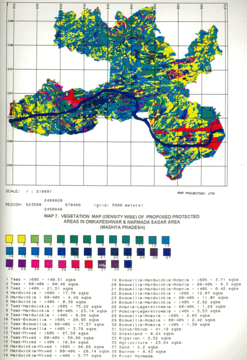
SPOT data (PLA with 10 X 10 m ground resolution) is the best available satellite data, to date. However, we had access to only SPOT MLA data (20 X 20 m ground resolution). During the field work correlation between density class of the forest cover and image characteristics was established. In some instances because of the thick under growth of broad leaved shrubs, the open forest appeared as dense forest (pseudo-density). Canopy cover appearing in smooth texture, without soil being exposed, were delineated as canopy closure >60%, similarly, areas with medium to coarse texture were delineated as density class 60-40% and areas with very coarse texture were delineated as density class <40 % (Map 7).
A quick look into the area analysis of those PPAs based on the density classes indicates that all of them have highest percentage of the density class >60 %. Similarly, the density classes 60-40 % and <40 % are the second and third highest areas respectively. Omkareshwar Sanctuary has about 41.28 %, Narmada National Park has about 57.29 % and Surmanya Sanctuary has 63. 82 % of the forest area under close canopy cover (>60 %). Table 7 shows the areas under the PPAs in different density classes.
Table 7. Comparison of area based on density under different PPAs.
| |
Narmada National Park |
Omkareshwar Sanctuary |
Surmanya Sanctuary |
| Canopy Cover |
>60% |
60-40% |
<40% |
>60% |
60-40% |
<40% |
>60% |
60-40% |
<40% |
| Area (km2) |
179.26 |
125.15 |
32.64 |
49.52 |
32.46 |
14.69 |
104.48 |
38.53 |
9.27 |
| Area (%) |
57.29 |
26.34 |
6.87 |
41.28 |
27.06 |
12.25 |
63.82 |
24.54 |
5.66 |
4.4.2.1 Proposed Omkareshwar Sanctuary
The proposed sanctuary has maximum area under Teak and Teak mixed forest. Teak forest occurs in about 37.4 km2 and Teak mixed with different species occur in 42.19 km2 out of the total sanctuary area of 119.96 km2. Hardwickia, the most interesting species occurs in pure patches in a area of about 3.49 km2 (2.9%) and mixed with other tree species in an area about 25.62 km2 (21.33%). A good proportion of area i.e. 14.81 km2 (12.34%) is under scrub/shrub. Forest area with > 60% is about 49.52 km2 (41.28 %). Table 8 provides area analysis of the forest cover density wise.
4.4.2.2 Proposed Narmada National Park
The proposed National Park has a very good forest cover under Teak. Teak forests with> 60% density have an area of about 83.61 km2 (17.59 %). Total area under pure Teak forest is 128.96 km2 (25.29 %). Teak mixed with other species occurs in an area of 312.83 km2 (63.89%). Hardwickia forest occurs in an area about 13 km2 (2.72 %) in pure patches and mixed with other species in an area about 165.76 km2 (34.21 %). The area also has more plant associations and density classes as compared to the other proposed areas for conservation and protection. Scrub/shrub occurs in an area about 14.81 km2 (12.34 %). Forest area under >60% canopy closure is 272.97 km2 (57.29 %). Table 9 gives the area details.
Table 8. Area of Vegetation Types in the Proposed Omkareshwar Sanctuary.
| S.N. |
Vegetation Types |
Area (km) |
Area % |
| 1. |
Teak> 60% |
14.82 |
12.35 |
| 2. |
Teak 60 - 40% |
12.09 |
10.07 |
| 3. |
Teak < 40% |
10.49 |
8.70 |
| 4. |
Hardwickia > 60% |
2.73 |
2.27 |
| 5. |
Hardwickia 60 - 40% |
0.76 |
0.63 |
| 6. |
Teak-Hardwickia > 60% |
8.97 |
7.47 |
| 7. |
Teak-Hardwickia 60 - 40% |
1.66 |
1.38 |
| 8. |
Teak-Hardwickia < 40% |
1.74 |
1.45 |
| 9. |
Teak-Boswellia> 60% |
4.58 |
3.81 |
| 10. |
Teak-Boswellia 60 - 40% |
5.55 |
4.63 |
| 11. |
Teak-Boswellia< 40% |
0.95 |
0.79 |
| 12. |
Teak-mixed> 60% |
10.90 |
9.08 |
| 13. |
Teak-mixed 60 - 40% |
6.81 |
5.68 |
| 14. |
Teak-mixed < 40%. |
1.03 |
0.86 |
| 15. |
Hardwickia-Mixed > 60% |
6.13 |
5.11 |
| 16. |
Hardwickia-Mixed 60 - 40% |
2.44 |
2.03 |
| 17. |
Hardwickia-Mixed < 40% |
0.48 |
0.40 |
| 18. |
Boswellia-Hardwickia-Acacia > 60% |
0.78 |
0.65 |
| 19. |
Boswellia-Hardwickia-Acacia 60-40% |
2.09 |
1.74 |
| 20. |
Boswellia-Hardwickia > 60% |
0.28 |
0.23 |
| 21. |
Boswellia-Hardwickia 60 - 40% |
0.73 |
0.60 |
| 22. |
Boswellia-Acacia> 60% |
0.33 |
0.27 |
| 23. |
Boswellia-Acacia 60 - 40% |
0.33 |
0.27 |
| 24. |
Scrub/Shrub |
14.81 |
12.34 |
| 25. |
Riparian |
0.02 |
0.01 |
| 26. |
Agriculture |
4.91 |
4.09 |
| 27. |
Sand |
1.92 |
1.60 |
| 28. |
Barren |
1.45 |
1.20 |
| Total |
119.96 |
99.71 |
Table 9. Area of Vegetation Types in the Proposed Narmada National Park.
4.4.2.3 Proposed Surmanya Sanctuary
The Surmanya sanctuary being proposed on the northern boundary of the Narmada national park, will act as a "buffer". The area has about 56.06 km2 (34.24 %) under pure Teak and about 69.74 km2 (42.55 %) under mixed Teak forest Hardwickia forest occurs in pure patches in about 5.98 km2 (0.73 %) and in mixed form with other tree species in an area about 42.47 km2 (25.92%). The area has about 104.48 km2 (63.82 %) under> 60 % canopy closure. Scrub/shrub area is less i.e. 7.77 km2 (4.74 %). There is no agriculture/habitation in the area. The area also does not have riparian forest and water body. Table 10 gives the details of the areas.
4.4.2.4 Submergence of forest cover in PPAs
Out of 758.88 km2 of the area proposed for protection in the form of PPAs 142.84 km2 will be submerged at FRL (full reservoir level) i.e. 262.5 m from m.s.l. Thus PPAs will have about 18 % of the total area under submergence. Wild animals will be able to meet their drinking water requirement within the protected areas (Map 4).
Submergence areas will be up to the height of 262.5 m from m.s.l. in the valleys, valley plains and slopes of the hills. About 20.28 km2 of agriculture will be submerged. Large forest areas under submergence will be 24.254 km2 (16.98 %) of Teak forest, 17.089 km2 (11.96 %) of Hardwickia mixed; forest, 16.236 km2 (11.37 %) of Teak-Hardwickia and 15.687 km2 (10.98 %) of Teak mixed forests.: Submergence is likely to change the floristic structure of these forests, because of raising of ground, water level and waterlogging. Table 11 provides the different areas of forest cover and land use going to be submerged.
Table 10. Area of Vegetation Types in the Proposed Surmanya Sanctuary
| S.N. |
Vegetation Types |
Area (km2) |
Area % |
| 1. |
Teak> 60% |
42.04 |
25.68 |
| 2. |
Teak 60 - 40% |
11.76 |
7.18 |
| 3. |
Teak < 40% |
2.26 |
1.38 |
| 4. |
Hardwickia > 60% |
4.93 |
3.01 |
| 5. |
Hardwickia 60 - 40% |
1.05 |
0.64 |
| 6. |
Hardwickia < 40% |
0.16 |
0.09 |
| 7. |
Teak-Hardwickia > 60% |
15.70 |
9.59 |
| 8. |
Teak-Hardwickia 60 - 40% |
5.42 |
3.31 |
| 9. |
Teak-Hardwickia < 40% |
1.32 |
0.80 |
| 10. |
Teak-Boswellia > 60% |
3.94 |
2.40 |
| 11. |
Teak-Boswellia 60- 40% |
1.44 |
0.87 |
| 12. |
Teak-Boswellia < 40% |
0.94' |
0.57 |
| 13. |
Teak-mixed> 60% |
25.18 |
15.38 |
| 14. |
Teak-mixed 60 - 40% |
12.79 |
7.80 |
| 15. |
Teak-mixed <40% |
3.01 |
1.83 |
| 16. |
Hardwickia-Mixed > 60% |
12.07 |
7.37 |
| 17. |
Hardwickia-Mixed 60 - 40% |
5.13 |
3.13 |
| 18. |
Hardwickia-Mixed <40% |
0.85 |
0.52 |
| 19. |
Boswellia-Hardwickia-Acacia 60-40% |
0.62 |
0.38 |
| 20. |
Boswellia-Hardwickia > 60% |
0.60 |
0.36 |
| 21. |
Boswellia-Hardwickia 60 - 40% |
0.66 |
0.40 |
| 22. |
Boswellia-Hardwickia < 40% |
0.10 |
0.06 |
| 23. |
Acacia-Lagerstroemia 60 - 40% |
0.28 |
0.17 |
| 24. |
Acacia-Lagerstroemia <40% |
0.57 |
0.34 |
| 25. |
Boswellia-Acacia > 60% |
0.02 |
0.12 |
| 26. |
Boswellia-Acacia <40% |
0.06 |
0.03 |
| 27. |
Scrub/Shrub |
7.77 |
4.74 |
| 28. |
Sand |
0.05 |
0.03 |
| 29. |
Barren |
2.88 |
1.75 |
| Total |
163.70 |
99.93 |
Table 11. Vegetation Types in the Submergence Areas of Proposed Protected Areas (Islands are excluded)
| S.N. |
Vegetation Types |
Area (km2) |
Area % |
| 1. |
Teak |
24.25 |
16.98 |
| 2. |
Hardwickia |
3.74 |
2.62 |
| 3. |
Teak-Hardwickia |
16.23 |
11.37 |
| 4. |
Teak-Boswellia |
5.58 |
3.91 |
| 5. |
Boswellia-Hardwickia |
3.17 |
2.22 |
| 6. |
Boswellia-Acacia |
0.73 |
0.51 |
| 7. |
Acacia-Lagerstroemia |
0.01 |
0.01 |
| 8. |
Boswellia-Hardwickia-Acacia |
0.65 |
0.04 |
| 9. |
Teak-mixed |
15.68 |
10.98 |
| 10. |
Hardwickia Mixed |
17.08 |
11.96 |
| 11. |
Scrub/Shrub |
6.89 |
4.83 |
| 12. |
Riparian |
0.55 |
0.39 |
| 13. |
Agriculture |
20.28 |
14.20 |
| 14. |
Sand |
1.67 |
1.17 |
| 15. |
Barren |
0.73 |
0.51 |
| 16. |
River Narmada |
25.51 |
17.86 |
| TOTAL |
142.84 |
99.99 |
|


