|
Geomorphology can be defined as a study of landforms. Landforms are the result of the interaction of different processes which exert energy on earth material resulting in the formation of landforms. Geomorphological studies have different application capabilities especially in the field of soil sciences, forestry and geology. With the advent of satellite technology, this branch of earth sciences has gained vast importance and priority. Remote sensing gives a synoptic view of the earth and hence facilitates comprehensive view of earth which aids in geomorphological mapping. The temporal and spatial capability of satellite data can be effectively used to understand the dynamic processes and spatial distribution of landforms. Landforms exert a direct control over the geomorphological process, soil types and its environmental impact.
6.1 OBJECTIVES
The principal objective of this component of the project was Geomorphological mapping of the study area in 1:50,000 scale using SPOT Geocoded satellite data.
6.2 PHYSIOGRAPHY
The basin has undulating topography with linear valleys, plateaux and hills as the dominant physiography unit. The average mean height varies between 220 to 440 m. Highest elevation is 440m. The gorge across which the dam is proposed to be built is about 100m deep and 650ni wide at top. . The topography of river bed is irregular because of rocky braided islands.
6.3 DRAINAGE
Narmada river is the major river in the study area on which the dam is being built. This is the fifth largest river in India and originates at Amarkantak in Shahdol district and flows through Madhya Pradesh, Gujarat and Maharashtra, to discharge itself into the Arabian sea. It has total length of 1312 km from its origin to sea. The river is the largest westerly flowing river in India. Near the dam site the trend of river is West-North-West. This river is flowing along geologically weak plane. Hence, in most of its course in the study area it has a straight trend with less meandering. The major tributaries meeting this river in the study area are Pipalghat Nala, Chhota Tawa, Khari Nadi, Berakhal Nala and Bharanga Nala (Map 3).
6.4 METHODOLOGY
6.4.1 Interpretation of Satellite Imagery
Visual interpretation techniques using optical instruments were applied to interpret the satellite images. During interpretation, image interpretation keys like colour, tone, texture, shape, pattern and association were taken into account. The Survey of India toposheets were used for base map preparation. The thematic information interpreted from satellite data was transferred to base map for final registration.
6.4.2 Field Work
Ground checks for geomorphology were carried out in the month of September'93. The total field work was carried out in a period of 10 days. The ground traverses were taken wherever accessibility was possible, because of forested terrain. During the ground traverses various parameters collected were strike and dip of rock, rock sample analysis using hand lens, identification of major lithology. Confirmation of certain lithostatigraphy contact like the contact between Vindhyan and Bijawar was difficult to interpret from satellite data. These information were incorporated in the thematic maps wherever required.
6.4.3 Final Map
The post field work geomorphological map details are transferred into 1:50,000 scale base maps. The final geomorphological maps were prepared.
6.5 RESULTS AND DISCUSSION
6.5.1 General Geology of Vindhyans in Central India
The general geology of central part of India is given below in Table 17.
Table 17. Geological Characteristics of Central India.
| GROUP |
ROCK TYPE |
AGE |
| Alluvium |
|
Recent |
| Deccan Traps |
Basalt |
Late Cretaceous |
| Gondwanas |
Sandstone and Shale |
Upper Carboniferous to middle |
| Vindhyans |
Sandstones and Shale |
Late Precambrian |
| Bijawars |
Quartzite and phyllite |
Early Precambrians |
| Archaens |
Granites |
|
6.5.2 Geology of the Study Area
The study area lies in the central part of India. The rock formations present in the study area are the Vindhyan sedimentary rocks and the Bijawars. Bijawars include quartzite breccia, interbanded with conglomerate. The Vindhyan sedimentary consists mostly of sandstone, quartzites and conglomerates. They consist of underformed and unmetamorphosed sub-horizontal sedimentary beds lithology and structure have played an important role in giving rise to geomorphic forms in the area. Sandstones are mostly exposed as ridges whereas shale occupy the valley portion. Plateau, mesa, Hogback and cuesta are common 'structural land forms in the area which is the result of dipping strata. The Vindhyan super group is divided into lower Vindhyans and upper Vindhyans. The lower Vindhyans consists of Semri group which is argillaceous and calcareous. The upper Vindhyan consists of Kaimur, Rewa and Bhander group. They are mostly argello-calcareous. The Vindhyan group has mostly shallow water deposition sedimentary bodies which exhibit rill marks, mud cracks and rain imprints. The study area consists mostly of rocks belonging to upper Vindhyan (Plates 11, 12, 14, 15 and 16).
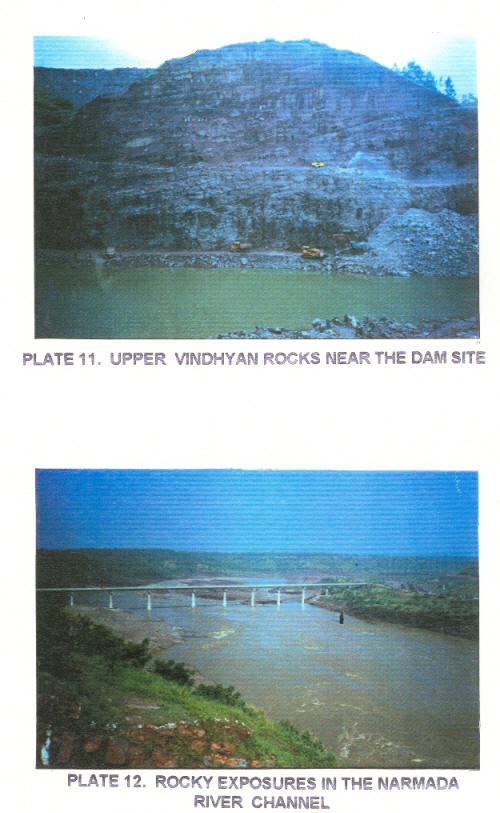
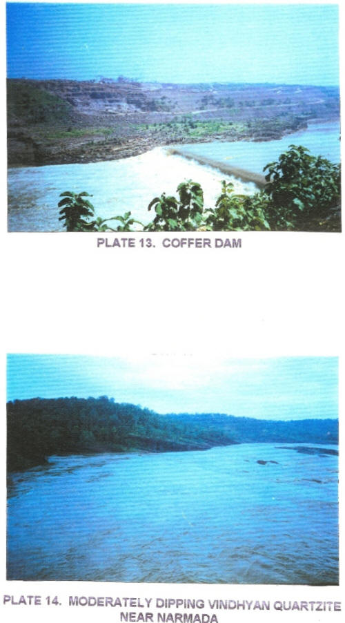
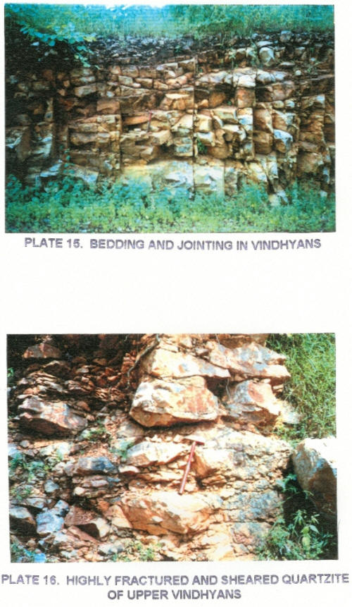
The Narmada has a straight course in the study area with south westerly flow but near the dam site it becomes West-North-West indicating a major structural control of the stream. All along the course Vindhyans are exposed on either bank. Near the dam site the Narmada flows in a steep gorge which is 100 m deep and 650 m wide.
6.5.3 Geomorphology of the Study Area
The geomorphology of Vindhyan plateau is complex consisting of residual hill of Vindhyan made up of nearly horizontal beds of sandstones and quartzites. These were covered by Deccan traps. As the denudation proceeded the overlying flows were gradually removed and underlying Vindhyans were exposed. The topography is generally undulating and rolling and as such there are no steep slopes. The structural fabric of the area, most prominently the strike and dip, has played a dominating role in sculpturing this landscape. The Vindhyan and Bijawar landscape is an inlier surrounded by younger Deccan trap rocks on all sides of the study area. This is because the most easily erodible Deccan traps which are made up of poorly consolidated intertrappean sedimentary beds and basalts is easily removed during the process of denudation. Perhaps the present topography is controlled largely by that existing before the volcancity which was modified by further erosion. The evolution of this paleo-landform which is fluvio-marine origin into hills and plateau are due to result of epirogenic movement. The basin is mostly of synclinal nature with the Narmada river flowing along the weak axis, which probably may be a fault (Plates 15, 17 and 18).
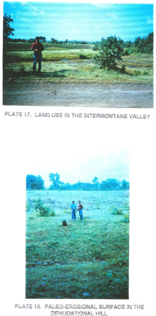
The major types of geomorphic features were identified and classified into two major classes taking the lithostatigraphy into account. On the basis of location, erosion, shape and slope which are represented by discrete tone and texture on the imagery the landform were divided and classified into subunits (Map 9). The actual classification scheme is given below:
(A) LITHOSTATIGRAPHY - UPPER VINDHYANS
| STRIKE RIDGES |
- |
SR |
| STRUCTURAL VALLEY |
- |
SV |
| BARREN DIP SLOPE |
- |
BDS |
| BARREN SCARP SLOPE |
- |
BSL |
| VEGETATED DIP SLOPE |
- |
VDS |
| VEGETATED SCARP SLOPE |
- |
VSS |
| VEGETATED PLATEAU |
- |
VPL |
| BARREN PLATEAU |
- |
BPL |
| HIGHLY DISSECTED HILL |
- |
HDH |
| MODERATELY DISSECTED HILL |
- |
MDH |
| LOW DISSECTED HILL |
- |
LDH |
| PEDIMENT |
- |
PD |
| INTERMONTANE VALLEY |
- |
IV |
| PLATEAU |
- |
PL |
(B) LITHOSTATIGRAPHY - BIJAWARS
| HIGHLY DISSECTED HILL |
- |
HDH |
| MODERATELY DISSECTED HILL |
- |
MDH |
| LOW DISSECTED HILL |
- |
LDH |
| STRIKE RIDGES |
- |
SR |
| VEGETATED PLATEAU |
- |
VPL |
| BARREN PLATEAU |
- |
BPL |
| INTERMONTANE VALLEY |
- |
IV |
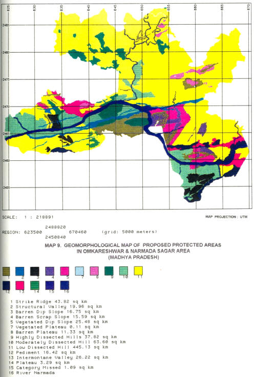
This classification scheme was followed to suit the user requirement. Hence, the land system classification was followed with certain modifications. The subunits like vegetated dip slope were included in the major units of hill, in order to facilitate easy interlinking of vegetation information in the GIS environment.
6.5.4 Description of Geomorphic Units
(i) Strike Ridges:
They are almost NE-SW trending ridges confirming mostly to the strike of the rock. They are mostly seen in upper Vindhyan formation. Due to removal of Basaltic capping the massive hard quartzite formation of Vindhyan is exposed as linear ridges. Some of the ridges have EW trend with steep slopes as is the case near Bharanga nala. This unit is densely forested. The strike ridges trending NE-SW have a gentle slope towards west and steep slope towards east. The Westward slope confirms to the Dip direction of the beds. The dip ranges between 15° to 30° NNW. The Vindhyan super layer generally consists of quartzite interbedded with sandstones and conglomerate. The quartzite forms the steep strike ridges. They exhibit typical cuesta landforms and flatiron topography. Flatiron indicates, the strike ridges of the Eastern portion of study area show westerly dip whereas the eastern ridges shows westerly dip. This confirms the synclinal nature of the basin.
(ii) Structural Valley:
These are linear valleys confirming to the structure of the rock. They are mostly trending along NNW-SSW. They confirm the weak structural plane of rock. The valley is mostly elongated. The area is cultivated. They are mostly seen in Vindhyan group of rock. South of Narmada river some of the valleys splay and broaden especially at the intersection of two lineaments.
(iii) Dip Slope (Barren and Vegetated):
The slope confirming to dip of formation is designated as Dip slope. Some of the slopes are Barren. Hence, termed as Barren dip slope. - The slope is gentle with 15° to 30° Dip.
(iv) Scarp Slope (Barren and Vegetated):
The lee slope of the hills opposite to dip slope is the scarp slope. These slopes are very steep. Some of slopes are vegetated while some are barren.
(v) Plateau:
Raised flat surfaces fringed with steep scarp slopes are termed as plateau. They have an elevation of 240-250 m. These are mostly seen in the Bijawars where the resistant rocks have formed extensive table land. Based on vegetation cover the plateau has been divided into Barren and Vegetated. In case the demarcation was difficult, it was classified as plateau.
(vi) Hills:
Rocky area exhibiting higher elevation than the surroundings is termed as hills. Based on dissection pattern and distribution hills are further divided into (a) Highly Dissected hills, (b) Moderately dissected hill and (c) Low dissected hill
(a) Highly dissected hill
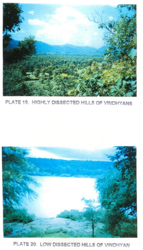
These are hills which have undergone severe dissection. The slopes are moderate to steep. Drainage density is medium to fine texture. They are thickly forested. These hills might have been subjected to resurrection process whereby exhibiting the paleo-erosional surface. Their height ranges between 220-240 m (Plate 19).
(b) Moderately dissected hill
These hills have gentle slope. The topography is more or less rolling and undulating. They are thickly forested. They are mostly quartzite and sandstone hills of Vindhyans and Bijawar with intervening valleys. The height ranges between 240-250 m.
(c) Low dissected hill
These are high hills with topographic height ranging between 240 to 400 m above MSL. They are thickly forested and they have maximum aerial coverage in the study area. They are rounded to flat topped hill with moderate slopes. They are highly jointed and fractured. Drainage is medium to fine texture indicating the compact nature of the strata (Plate 20).
(vii) Pediments:
These are seen mostly in foothills. They have undulating and rolling topography exposing the remnants of hard rocks. They are mostly seen south of Narmada where the hill ranges merge with eroded plain land of Deccan traps.
(viii) Intermontane Valley:
These are broad valley unlike the linear structural valley. Most of the important settlements are seen in these broad valleys. They have both the colluvium and alluvial deposits. Hence, it is a fertile plain which is extensively cultivated in this hilly and forested terrain. Some of these valleys are formed at the intersection point of two structural valleys where under the influence of two intersecting lineament the valley has broadened (Plate 17).
6.5.5 Geographic Details of the Area
The Geomorphological map for the study area was digitized in SUN Sparc station using GRASS software. The area coverage of different units were calculated and tabulated for three different protected areas in Tables 18, 19 and 20.
Table 18. Geomorphological Details of the Proposed Narmada National Park
| S.N. |
Category |
Area(km2) |
Area (%) |
| 1. |
LOW DISSECTED HILL |
253.21 |
53.28.. |
| 2. |
MODERATELY DISSECTED HILL |
57.07 |
12.10 |
| 3. |
HIGHLY DISSECTED HILL |
26.09 |
5.49 |
| 4. |
STRIKE RIDGE |
37.44 |
7.87 |
| 5. |
VEGETATED DIP SLOPE |
24.05 |
5.06 |
| 6. |
BARREN DIP SLOPE |
10.91 |
2.29 |
| 7. |
INTERMONTANE VALLEY |
14.06 |
2.95 |
| 8. |
BARREN SCARP SLOPE |
15.59 |
3.28 |
| 9. |
PEDIMENT |
14.24 |
2.99 |
| 10. |
BARREN PLATEAU |
4.13 |
0.86 |
| 11. |
PLATEAU |
3.18 |
0.67 |
| 12. |
STRUCTURAL VALLEY |
14.04 |
2.95 |
| 13. |
VEGETATED PLATEAU |
0.11 |
0.02 |
| 14. |
UNCLASSIFIED |
1.09 |
0.23 |
| Total |
475.22 |
100.00 |
Table 19. Geomorphological Details of the Proposed Surmanya Sanctuary
| S.N. |
Category |
Area (km2) |
Area (%) |
| 1. |
LOW DISSECTED HILL |
147.44 |
90.06 |
| 2. |
MODERATELY DISSECTED HILL |
0.00 |
0.00 |
| 3. |
HIGHLY DISSECTED HILL |
8.69 |
5.30 |
| 4. |
STRIKE RIDGE |
2.19 |
1.33 |
| 5. |
VEGETATED DIP SLOPE |
0.00 |
0.00 |
| 6. |
BARREN DIP SLOPE |
0.00 |
0.00 |
| 7. |
INTERMONTANE VALLEY |
0.00 |
0.00 |
| 8. |
BARREN SCARP SLOPE |
0.00 |
0.00 |
| 9. |
PEDIMENT |
0.00 |
0.00 |
| 10. |
BARREN PLATEAU |
5.38 |
3.29 |
| 11. |
PLATEAU |
0.00 |
0.00 |
| 12. |
STRUCTURAL VALLEY |
0.00 |
0.00 |
| 13. |
VEGETATED PLATEAU |
0.00 |
0.00 |
| 14. |
UNCLASSIFIED |
0.00 |
0.00 |
| Total |
163.70 |
98.9 |
Table 20. Geomorphological Details of the Proposed Omkareshwar Sanctuary
| S.N. |
Category |
Area (km2) |
Area (%) |
| 1. |
LOW DISSECTED HILL |
47.81 |
39.85 |
| 2. |
MODERATELY DISSECTED HILL |
36.52 |
30.44 |
| 3. |
HIGHLY DISSECTED HILL |
3.03 |
2.52 |
| 4. |
STRIKE RIDGE |
3.26 |
2.72 |
| 5. |
VEGETATED DIP SLOPE |
1.31 |
1.09 |
| 6. |
BARREN DIP SLOPE |
5.84 |
4.86 |
| 7. |
INTERMONTANE VALLEY |
12.16 |
10.13 |
| 8. |
BARREN SCARP SLOPE |
0.00 |
0.00 |
| 9. |
PEDIMENT |
2.17 |
1.80 |
| 10. |
BARREN PLATEAU |
1.83 |
1.52 |
| 11. |
PLATEAU |
0.11 |
0.10 |
| 12. |
STRUCTURAL VALLEY |
5.92 |
4.93 |
| 13. |
VEGETATED PLATEAU |
0.00 |
0.00 |
| 14. |
UNCLASSIFIED |
0.00 |
0.00 |
| Total |
119.96 |
99.96 |
In all the three proposed protected areas, the area occupied by low dissected hill was high.
6.6 CONCLUSION:
The present day topography of Vindhyans in the study area is due to upliftment, structural deformation and denudation. The Deccan traps which is younger to Vindhyan group of rock has eroded exposing the inlier patch of Vindhyan. Structure of rock has had a direct manifestation on the present day topography. The region is not much structurally distributed indicating epirogenic upliftment. The central portion of this syncline exhibit plateau indicating the horizontal disposition of bed. While the eastern and western portion of the study area exhibit cuesta landform, where the beds have dip ranging between 15° to 30°. The presence of sandstone and quartzite formation alternating with major bands of shale has resulted in strike ridges with bold erosional escarpment. The denudation of younger Deccan trap formation has exposed the exhumed surfaces of older Vindhyans. The geomorphic manifestation of Vindhyan group of rock and Bijawar in the form of low dissected hills confirm that the older formation denudation was low exhibiting the paleo erosional surface.
|


